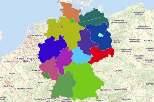
GERMAN STATES
- Territory Guide
- GERMAN STATES
Let your German states map dynamically produce results. This map is an essential tool in data and territory analyses that’s being popularly used by the health sector, business sector, and local governance.
In Mapline, it only takes a few seconds to generate a map showing all the states in Germany.
A CLOSER LOOK AT GERMAN STATES
You can easily create a Map of German States using Mapline. Germany, considered as the most populous country in Europe, is located in the western-central part of the continent. The states of Germany shoulder heavy responsibilities including arts and sciences, education and job training. They also exercise limited powers in international treaties. Germany is recognized for its great contributions in having large portions of specialized small and medium enterprises. Berlin, its capital and one of the 16 states, is a leading location for startup companies and venture capital funded firms.
Using Mapline, you can easily create a Map of German States. Mapline offers all 16 constituent states of Germany.
ADD GERMAN STATES TO MAP
Yes, you read it right. Add territories in seconds! Not hours, not minutes, but only in a few seconds! How is that possible?
Click the ADD button on the left panel of your map then click FROM MAPLINE’S REPOSITORY. In the search bar, type GERMANY and select STATES.
Once added, be in the know about the socio-political factors and other opportunities that you may have missed without the state boundaries plotted on your map.


Pro Tip: Aside from the state boundaries, Mapline also offers other Germany territories that you can readily overlay on your map. These are administrative regions, districts, and postcodes.
CHOOSE STATE COLORS
Unravel trends, ideas, and patterns that you may have overlooked before. How? Simply by assigning colors to your territories! This leads you to discover time-sensitive information that you may want to address right away.
Choose the color style that best fits your type of analysis. Then hit OK and that’s it! You have generated a map of German states that easy!

GET NEW TERRITORY INSIGHTS
Once you have your map, you can create a map of Excel spreadsheet locations to overlay on top. Mapline also makes it simple to see summary information about the locations inside each state just by clicking on them! Sign up now to create a Map of German States.


