NEPAL ZONES
- Territory Guide
- NEPAL ZONES
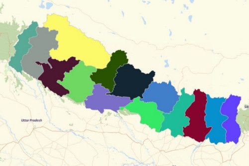
Create a map of Nepal zones to construct realistic business plans. Once you have your map up and running, start adding your data and see connections between your data and territory boundaries.
See for yourself how beneficial having this kind of map for business planning.
A CLOSER LOOK AT NEPAL ZONES
You can easily create a map of Nepal zones using Mapline. Nepal is the home of 8 of the 10 world’s highest mountains. Among them is Mount Everest (known in the country as “Sagamartha”), the highest mountain in the world. There are 14 administrative zones in the country which are grouped together to form 5 development regions.
Using Mapline, you can easily create a map of Nepal zones. The development regions of Nepal are each divided into 3 zones except for Far-Western Development Region which only has 2 zones. Karnali Zone located in the Mid-Western Development Region is the country’s largest zone. Meanwhile, Mahakali Zone in the Far-Western Development Region is said to be the smallest zone in the country.
ADD NEPAL ZONES TO MAP
Being a business owner, of course you want to see how your day to day operation goes. Luckily, we have a map for that. Mapline makes it the easiest to overlay territories on a map so you can focus on the more important things – overseeing your operations, taking care of the business side, and more!
To do that, start by adding territories FROM MAPLINE’S REPOSITORY located at the left side of your map when yhou click the ADD button.
In the search bar, type NEPAL to show you all the territories available for Nepal. Then, select NEPAL ZONES.


Pro Tip: Aside from the zone territories, Mapline provides other territory boundaries for Nepal like regions, districts, and villages.
CHOOSE ZONE COLORS
Don’t be easily satisfied by just adding territories. In fact, you can see your territories in a different light as you add colors to them.
There are a lot of advantages in adding colors to your territories. Yes it will make your map look more aesthetically appealing, but that’s not all! You can actually be empowered to identify ideas for informed decisions. So you can present the best solutions in your sales, deliveries, and even reducing and managing risks.
That’s the power of adding territory colors! So go ahead, pick the best color style that fit your analysis.

GET NEW TERRITORY INSIGHTS
That’s how easy it is to create a map of Nepal zones! Once you have your map, you can create a map of Excel spreadsheet locations to overlay on top. Mapline also makes it simple to see summary information about the locations inside each zone just by clicking on them! Sign up now to create a map of Nepal zones.


