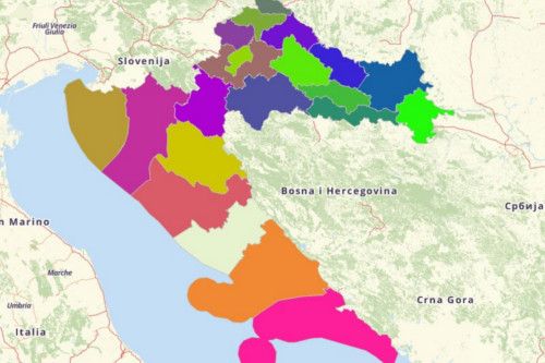
CROATIA COUNTIES
- Territory Guide
- CROATIA COUNTIES
Many companies from different industries rely on a map of Croatia counties in more ways than one. Since the county boundaries are smaller compared to province or regional boundaries, it opens a gateway for them to view their data in local settings. If you want to know more about the ins and outs of each county, then add this territory now!
Don’t worry, we’ll help you create and maximize the uses of a map of Croatia counties.
A CLOSER LOOK AT CROATIA COUNTIES
You can easily create a map of Croatia counties using Mapline. The Republic of Croatia is made up of 20 counties and Zagreb, the capital city which functions as a county and a city at the same time. Counties are the 1st level administrative divisions of the country. Each county has an executive branch of government ruled by an elected county prefect. Since Zagreb is a city, it is headed by a city mayor.
Using Mapline, you can easily create a map of Croatia counties. There are 21 counties in all (including the city of Zagreb) in Croatia which are further divided into 127 cities, 429 municipalities and 6,749 settlements.
ADD CROATIA COUNTIES TO MAP
Since location is the most important in business, learning everything about the landscape of each county gives you the edge to outperform the competition. A county-level analysis makes your eyes grow wider as you identify growth opportunities, improve your marketing strategies, and reach out to your loyal customers.
You can accomplish all that and more once you start adding territories to your map. Click the ADD button to access territories from MAPLINE’S REPOSITORY. Then, in the search bar, type CROATIA and choose CROATIA COUNTIES.


Pro Tip: Mapline offers the cities and munitipalities of Croatia aside from counties.
CHOOSE COUNTY COLORS
One last step and you’re good to go. The next step is to add colors to your territories!
Whether you’re analyzing customer demographic, or contemplating on business expansion, or thinking to improve your customer service, color styles is a definite help to ignite ideas so you can provide the best solutions for all those concerns.
Choose from the great color style options – random colors, uniform color, custom-color from your spreadsheet, and heatmap colors. Once you’re decided what color style to choose, hit OK and you’ll be having your own map of Croatia counties right before your eyes.

GET NEW TERRITORY INSIGHTS
That’s how easy it is to create a map of Croatia counties! Once you have your map, you can create a map of Excel spreadsheet locations to overlay on top. Mapline also makes it simple to see summary information about the locations inside each county just by clicking on them! Sign up now to create a map of Croatia counties.


