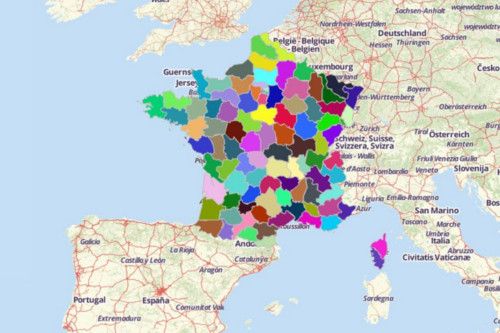
FRENCH DEPARTMENTS
- Territory Guide
- FRENCH DEPARTMENTS
Great news! French departments can now be added to your map in just a few seconds! Analyzing this territory is so useful to many companies in different industries especially in the franchise industry. They can monitor their stores, the buying patterns of the customers on each department, or understand the risk factors in their operations.
Get started now on mapping French departments so you won’t miss a thing in running your franchise business!
A CLOSER LOOK AT FRENCH DEPARTMENTS
France is one of the most modern countries in the world. It is also considered as a leader among European nations. Aside from the 96 departments located in the metropolitan area, there are also 5 overseas departments of France. These are French Guiana, Guadeloupe, Martinique, Mayotte, and Réunion. The departments are further divided into 335 arrondissements (which function as a district).
Using Mapline, you can easily create a map of French departments. The main responsibilities of departments include management of:
- Social and welfare allowances
- Junior high school buildings and technical staff
- Local roads
- School and rural buses
- Municipal infrastructures
ADD FRENCH DEPARTMENTS TO MAP
Adding French Departments is never too complicated with Mapline. In fact, all you need to do is to follow this simple guide .
Choose the territory FROM MAPLINE’S REPOSITORY. UItilize the search bar to type in FRENCH an automatically, the selection will show you FRENCH DEPARTMENT. Click that and you’re good to go.


Pro Tip: Aside from the department boundaries of France, Mapline also provides other territory boundaries for France, These include IRIS areas, cantons, regions, and postal codes.
CHOOSE DEPARTMENT COLORS
If you want to create a map with a powerful impact, start adding colors to your territory boundaries. Being aesthetically pleasant is just the icing on the cake. Once you add colors, you open the gates where ideas come naturally coming in, These ideas lead to informed decisions as you run your business seamlessly.
Mapline gives you the best color styles to choose from. Whether you want random colors or custom colors from your spreadsheet, or even heatmap colors, you’ll never go wrong with picking a color style that matches your analysis.

GET NEW TERRITORY INSIGHTS
That’s how easy it is to create a map of French departments! Once you have your map, you can create a map of Excel spreadsheet locations to overlay on top. Mapline also makes it simple to see summary information about the locations inside each department just by clicking on them! Sign up now to create a map of French departments.


