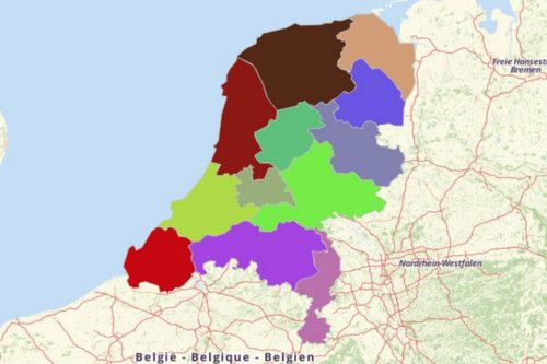
THE NETHERLANDS PROVINCES
- Territory Guide
- THE NETHERLANDS PROVINCES
While it is true that a map of The Netherlands Provinces is often being used for national and local government purposes, it is also true that it is used beyond those scope. In fact, provincial mapping is crucial when analyzing the impacts of territory insights to businesses and operations.
Still doubting? Why not try adding the provincial boundaries to your map? See for yourself what, where, and how you can discover insights between lines and borders?
A CLOSER LOOK AT THE NETHERLANDS PROVINCES
The Netherlands is a small country located in Western Europe. It also covers 3 island territories in the Caribbean. The name “Netherlands” literally means “Lower Countries,” because of its lowland geography. This country is known as the “Gateway to Europe ” because its location is strategically available for major rivers of Europe to freely flow through the sea. The Netherlands owes much of its prosperity to water that’s why it became the 2nd largest exporter of food and agricultural products in the world. The land is well suited for agriculture, horticulture, and cattle raising.
Using Mapline, you can easily create a map of Netherlands provinces. The Netherlands consists of 12 provinces and is further divided into 393 municipalities.
ADD PROVINCES OF THE NETHERLANDS TO MAP
With the provincial boundaries added to your map of demographic data, visualize opportunites and threats instantly. Then, act immediately to mitigate them. The powerful visualization your map allows you to monitor and manage territories per province especially in difficult situations.
Create a territory map with an impact! Start your province-level mapping by selecting TERRITORIES from the MAPLINE’S REPOSITORY. Follow this simple step-by-step instruction to add all the provinces to your map in no time.
Just type the keyword NETHERLANDS in the search bar to get the quickest result. Then choose NETHERLANDS PROVINCES.


Pro Tip: Aside from provincial boundaries, Mapline also provides other territory boundaries for the Netherlands such as municipalities and constituent countries.
CHOOSE PROVINCIAL COLORS
Now, to get the maximum benefits from your map of the Netherlands provinces, add the best color style for your territories .
Present the current activities of individual province indicated by random colors, uniform color, heatmap colors, or custom colors from your spreadsheet. Unravel valuable insights once colors are added to your map.
When you’re satisfied with your color choice, click OK.

GET NEW TERRITORY INSIGHTS
That’s how easy it is to create a map of Netherlands provinces! Once you have your map, you can create a map of Excel spreadsheet locations to overlay on top. Mapline also makes it simple to see summary information about the locations inside each province just by clicking on them! Sign up now to create a map of Netherlands provinces.


