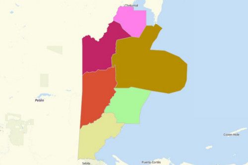
BELIZE DISTRICTS
- Territory Guide
- BELIZE DISTRICTS
If you’re looking for a great way to boost your brand presence and marketing approach, then it’s time to consider creating a map of Belize Districts.
Whether you’re in a real estate industry, or a franchise operator, or an environmental researcher, having a detailed map of district territories can be a game-changer for your brand. It allows you to identify potential target areas because you have a deeper knowledge on the ins and outs of each district.
Go ahead, create your map now. We’ll guide you from step 1 all throughout.
A CLOSER LOOK AT BELIZE DISTRICTS
You can easily create a map of Belize districts using Mapline. Belize is located on the eastern coast of Central America. With an average annual population growth of 1.87%, the country has the lowest population density in Central America.
Using Mapline, you can easily create a map of Belize districts. Belize is divided into 6 districts: Belize, Cayo, Orange Walk, Corozal Stann Creek, and Toledo. The districts are further divided into 31 constituencies. Belize District is the most populous with more than 89,000 in population while the Cayo District is the largest in size (5,338 square kilometers).
ADD BELIZE DISTRICTS TO MAP
Tap into the power of adding Belize districts to your map to become an industry leader. How? Just add a territory using this guide. From Mapline’s Repository, search for BELIZE using the search bar. Then choose BELIZE DISTRICTS.
With district boundaries plotted on a map, seamlessly craft location-focused business plans, analyze district trends, optimize routes, and so much more!
You’re almost done. Just one step remaining.


Pro Tip:
CHOOSE DISTRICT COLORS
The last step to create a map of Belize districts is to style your territories with colors. You have the power to choose from different color options like custom colors,static colors, and dynamic colors.
When you’re done, click OK, your map is ready to use.

GET NEW TERRITORY INSIGHTS
That’s how easy it is to create a map showing all the districts of Belize! Once you have your map, you can create a map of Excel spreadsheet locations to overlay on top. Mapline also makes it simple to see summary information about the locations inside each district just by clicking on them! Sign up now to create a map of Belize districts.


