CHILE PROVINCES
- Territory Guide
- CHILE PROVINCES
A map of Chile Provinces is very useful in so many ways. Without this territory boundary added to your map, it will be more difficult to uncover ideas during territory analysis. What else can you achieve by adding this territory?
Fast track your data and territory analysis as you start adding this territory now!
A CLOSER LOOK AT CHILE PROVINCES
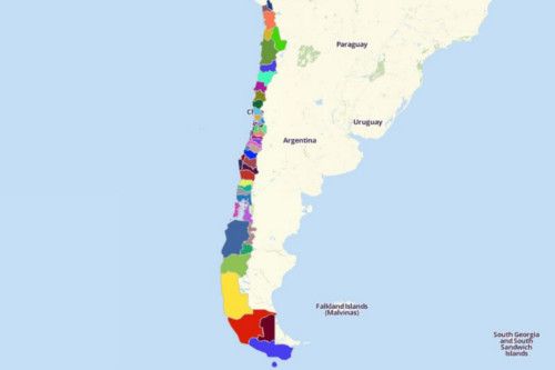
Chile’s unique and long narrow strip of line lies in South America. It consists of 54 provinces. In Chile, a province is the 2nd largest administrative division, next to the region. It is headed by a provincial governor. Chile’s provinces are further divided into 346 communes which are administered by mayors and their municipal councils.
ADD CHILE PROVINCES TO MAP
If you’re a business owner who struggles to identify potentials in different provincial areas, then then this territory is perfect for you!
Never go awry again when it comes to territory analysis. With provincial boundaries plotted on your map, capture insights instantly. The visualization is so clear that you instantly notice where your customers are, your potential markets, and where to strategically allocate your resources.
That’s totally awesome, right? Start adding territories now so you’ll gain greater ideas ahead.
Access Mapline’s Repository and search for CHILE. Then, select CHILE PROVINCES.


Pro Tip: Mapline stores a long list of territory boundaries available for Chile. You may want to check out other territories like regions and communes.
CHOOSE PROVINCIAL COLORS
Achieve more relevant insights as you add colors to your territories.
Colors add impact to your analysis. Once added, easily visualize business trends and variables to apply to your business operations.
Select the color style for your territories – custom colors from spreadsheet, heat map colors, uniform color, and random colors. When you’re done, hit OK and then that’s it! You have created a map of Chile Provinces to work to your advantage!

GET NEW TERRITORY INSIGHTS
That’s how easy it is to create a map showing all the provinces of Chile! Once you have your map, you can create a map of Excel spreadsheet locations to overlay on top. Mapline also makes it simple to see summary information about the locations inside each province just by clicking on them! Sign up now to create a Chile Provinces map.


