CORE BASED STATISTICAL AREA
- Territory Guide
- CORE BASED STATISTICAL AREA
It has been a continuous goal of Mapline to design and develop mapping tools that are easy to use yet produce powerful results. One way is to make US geographical territories be available to use. Since you asked for it, we gave you the very best answer! After all, Mapline wouldn’t be the best territory mapping software for nothing. Territories defined by the Census Bureau can now be used for mapping. So now, you can create a CBSA map in under a minute.
A CLOSER LOOK AT THE CORE BASED STATISTICAL AREA
The Core Based Statistical Area or CBSA is defined by the US Office of the Management and Budget (OMB) as a geographic area consisting of one or more counties with an urban center with a population of not less than 10,000. It should also have adjoining counties that are connected to the urban center by commuting. It took effect in June 2003. Currently, there are 927 CBSA in the US.
An area can be considered as CBSA if it has one of these characteristics:
- Metropolitan Statistical Areas with at least 50,000 population or more
- Micropolitan Statistical Area with at least 10,000 – 50,000 in population
- Combined Statistical Area combining adjacent Metropolitan or Micropolitan areas
ADD CBSA TO MAP
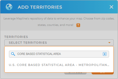
Add the territory from MAPLINE’S REPOSITORY.
Use the search bar to type the keyword CORE and it will show you the right territory boundary.


Pro Tip: Core Based Statistical Area (CBSA) refers to an urban geographic area with at least 10,000 people. Its surrounding areas are socio-economically connected to the urban center by commuting. Areas are defined by the Office of Management and Budget (OMB).
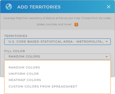
CHOOSE CBSA COLORS
Choose the best color styles for your territories.
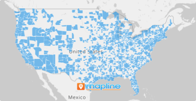
Just select the type of territory colors you need, and click OK. And there you go! You just created your very own map of Core Based Statistical Area.

GET NEW TERRITORY INSIGHTS
That’s how easy it is to create a US Core Based Statistical Area map! Once you have your map, you can create a map of Excel spreadsheet locations to overlay on top. Mapline also makes it simple to see summary information about the locations inside each statistical area just by clicking on them!
Sign up now and experience firsthand the Mapline advantage of creating emergency plans with data-driven solutions.


