Close
WE'RE ALL ABOUT
YOUR
SUCCESS
HOW WOULD YOU LIKE TO GET IN TOUCH:
Email
Email
Calendar
Cal
Close
WE'RE ALL ABOUT
YOUR
SUCCESS
HOW WOULD YOU LIKE TO GET IN TOUCH TO SCHEDULE YOUR DEMO:
Email
Email
Calendar
Cal
Mapline - mapping made powerful Close
Give us a call. We'd love to talk!

+1 800.969.1454

Close
Close
Geo Mapping Starter Close

Experience the power

Get ready to see your data in a whole new way!

Get a Closer Look at Your Data with Territory Mapping

Our territory mapping tool lets you add map boundaries to your territories like state, county, zip code, area code, and more. With boundary mapping, you can easily identify area trends and have greater visibility into your geographic performance.

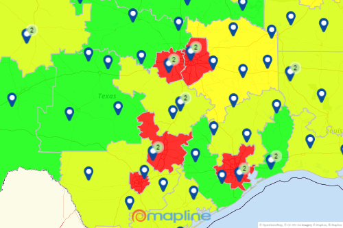
Territory maps help you to visualize your data

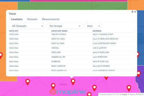
Territory and zip code mapping helps companies identify area trends, create sales territories, and report geographic performance. Mapline’s zip code mapping tool makes it easy to overlay a territory such as state, county, or zip code boundaries on a map. You can also use boundaries from hundreds of countries around the world. Then click on any territory (such as a specific county) to see a list of all the locations inside that territory shape!

Build a map of US states, counties, or zip codes

Adding boundaries to your mapped territories help you see important trends affecting your business and sales opportunities you can’t see within an Excel spreadsheet. These insights allow you to make strategic decisions around where the best and worst places are to do business.

Manage your territories like never before!

Mapline Logo
Mapping Made Powerful
Copyright Mapline Inc.
Sales: +1 800.969.1454