the world’s most
Geo-
efficient
Automated
deliveries

USE THE POWER OF GEOSPATIAL INTELLIGENCE TO MINIMIZE EXPENSES
AND MAXIMIZE ROI
HARNESS THE POWER OF GEOSPATIAL INTELLIGENCE TO MINIMIZE EXPENSES AND MAXIMIZE ROI
SEE WHAT THE EXCITEMENT IS ALL ABOUT SEE WHAT THE EXCITEMENT IS ALL ABOUT

Geospatial Analytics
- Instant maps of deliveries and customers
- Create operational territories
- Geo-capable charts, reports, dashboards
- Bulk distance calculations

Order Management
- Capture orders in the field
- Optimize order-to-delivery schedules
- Integrate sales and delivery logistics
- Monitor order fulfillment status
Delivery Confirmation
- Capture notes and pictures at each stop
- Geo fencing and location verification
- Electronic signatures and barcode scanning
- Automate confirmation emails and texts

Bid Management (3rd party logistics companies)
- Streamline RFP-to-proposal process
- Automatically generate proposals in seconds
- Configure price suggestions using driving distances
- Incorporate cost-drivers into pricing

Last-Mile Route Planning
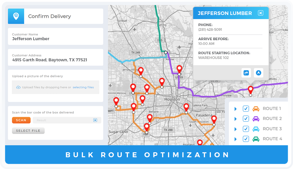
- Generate bulk routes
- Otpimize by drive time
- Reassign incomplete deliveries
- Accountability: breaks, delivery windows, driver qualifications, location requirements, vehicle capacities

Business Intelligence
- Driver and route statistics
- Snapshot of operations at any time
- Real-time cost and mileage reports
- Import data from anywhere
Vehicle Management
- Automate demand forecasting
- Identify driver and vehicle shortfalls
- Track vehicle maintenance schedules
- Optimize vehicle service area assignments
Visualize
WITH CHARTS, MAPS,
AND DASHBOARDS
AND DASHBOARDS

AUTOMATE
EVERYTHING WITH
WORKFLOWS
WORKFLOWS

COLLABORATION
AND CENTRALIZED
TEAM SHARING
TEAM SHARING

ANALYTICS
BI REPORTING
AND MONITORING
AND MONITORING

INSANELY CAPABLE
SIGNATURES, FORMS,
TEXTS, EMAILS, PHOTOS
TEXTS, EMAILS, PHOTOS
WHAT MAKES MAPLINE SO DIFFERENT?
WHAT MAKES MAPLINE SO DIFFERENT?
CUSTOMIZED
TO YOUR BUSINESS
TO YOUR BUSINESS



Mapline enables you to do business the way you’ve always envisioned! Built from tried and true components, our Master Builders work closely with you to configure a powerful operations system quickly and effectively. Mapline is the only software solution built from the ground-up on our innovative Geospatial technology that leverages the power of distance and location in your data. We let you see exactly where you are, then help you chart a course to where you want to be!
OUR GEOSPATIAL
ENGINE
ENGINE


Our proprietary Geospatial Engine is at the heart of our world-class BI platform — something no other analytics software can offer! Distance and location are crucial elements for enabling you to see clearly where to take your business next. Mapline is the only software solution built from the ground-up on our innovative Geospatial technology that leverages the power of distance and location in your data. We let you see exactly where you are, then help you chart a course to where you want to be!
GEO-ENRICHED
DATA
DATA



Fill in the gaps with powerful, Mapline-generated data! From demographics to advanced geospatial calculations, we enrich the data you already have with additional information that reveals fresh insights and helps you identify effective solutions. Mapline is the only software solution built from the ground-up on our innovative Geospatial technology that leverages the power of distance and location in your data. We let you see exactly where you are, then help you chart a course to where you want to be!
Don’t just take our word for it:


- “Mapline helped us save 47% on operating costs last quarter without changing our fleet size — to say we are thrilled is a huge understatement!”– Reed Kaus, Dir Support Services, Scooter’s Coffee
- “Interest rates have really impacted our business in the last year, and Mapline has even helped us visualize our fleet and combat inflation. It’s transformed our ability to reorganize quickly.”– Thomas Cox, Process Improvement, PAI
- “Mapline has helped us do a really great job of determining how many customers we can support in an area.”– Kyle Moody, Route Optimization, Royal Cup Coffee & Tea
- “It used to take us months to plan shifts in strategy, but now, Mapline takes that on for us. It’s been huge for our business.”– Thomas Cox, Process Improvement, PAI
- “I highly recommend Mapline to any business… The combination of their robust software and outstanding customer support makes them a top choice for optimizing operations and gaining actionable insights.”– Josh Chang, Head of Operations, Buncha
- “Now, we can calculate actual road miles from the customer location back to our warehouse [and] determine if a customer is worth the route.”– Kyle Moody, Route Optimization, Royal Cup Coffee & Tea
- I just started working with Mapline software this afternoon and WOW! I have been supported by so many incredible people… Great support, pleasant and extremely thorough.”– Wendy Lee, Project Manager/ Sales Operations, The RiteScreen


