What Are Geoanalytics Tools and Why Do They Matter?
Geoanalytics tools are software platforms that allow teams to visualize, analyze, and act on data using geographic context. Unlike traditional BI platforms that treat location as just another field, geoanalytics systems treat location as a first-class citizen—using spatial logic to expose patterns you’d never catch in a spreadsheet or static chart.
For businesses with field teams, distributed customers, supply chain networks, or territory structures, this kind of spatial intelligence isn’t optional—it’s foundational. And the benefits run deep:
- Faster decision-making: Map-based data reveals problems or opportunities instantly.
- Smarter territory planning: Visual boundaries help balance workload, revenue, or opportunity across regions.
- Improved performance tracking: See what’s working and where—by location, rep, or route.
- Increased operational efficiency: Route optimization and field alignment save time and money.
Great geoanalytics tools make complexity easier to manage—and more profitable to act on.

Pro Tip: Get more from your data with Mapline! Our Geo BI platform is built to give you all the power of GIS, without the complexity. It’s the fastest way to visualize, filter, and act on your business data—spatially. Whether you’re optimizing territories or analyzing campaign performance by region, Mapline’s drag-and-drop tools and instant map overlays make every decision clearer.
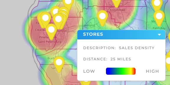
Analyze Spatial Patterns That Drive ROI
Whether you’re spotting underserved markets or high-performing zones, geoanalytics helps you uncover trends based on real-world geography. With spatial market analysis and map overlays, patterns become obvious that are completely invisible in table-based tools.

Territory and Routing Analytics
Geoanalytics software often includes built-in tools for territory planning and routing optimization. That means managers can adjust workloads, balance sales regions, or plan delivery/service routes without jumping between platforms or guessing based on zip codes alone.


GIS for Business, Minus the Complexity
While full GIS systems can be overwhelming or overbuilt for many teams, modern geo mapping and analysis platforms offer the power of GIS without the steep learning curve. That means faster setup, easier onboarding, and better adoption across departments.


Layering Data for Deeper Insight
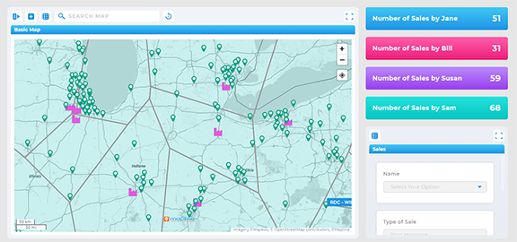
One of the most powerful features of geoanalytics tools is data layering. By stacking multiple datasets—like customer lists, revenue numbers, demographic insights, or competitor zones—teams can spot correlations and make decisions with confidence.
- Combine internal and external data like CRM records with census or ZIP-level data
- Use map overlay tools to visualize performance vs. opportunity zones
- Run comparative region-based analysis to see where performance lags or leads
Layering transforms your map into a strategic dashboard where relationships are visual, actionable, and dynamic.
Real-World Use Cases for Business Geoanalytics
Business geoanalytics isn’t limited to any one industry. Whether you’re managing a sales team, scheduling field technicians, or overseeing last-mile logistics, the use cases for spatial intelligence are broad—and growing:
- Sales teams: Design balanced territories, track rep performance, and target high-opportunity zones
- Operations: Route optimization, driver assignments, and regional workload balancing
- Marketing: Target campaigns by ZIP code, customer density, or demographic overlays
- Strategy teams: Perform regional growth analysis or market gap assessments
In short: If geography matters to your business, geoanalytics tools make your team smarter and faster.


What to Look For in a Geoanalytics Platform
There are plenty of spatial data platforms and tools out there, but not all geoanalytics software is created equal. Here are a few key features to look for:
- Real-time dashboards with location filters and region-based KPIs
- Custom mapping capabilities for territories, routes, and boundaries
- Interactive geo dashboards that work for both data analysts and field managers
- Data import flexibility from Excel, CRMs, and third-party APIs
A strong platform adapts to your workflow—not the other way around.