Close
WE'RE ALL ABOUT
YOUR
SUCCESS
HOW WOULD YOU LIKE TO GET IN TOUCH:
Email
Calendar
Close
READY FOR MAPLINE TO
ROCK
YOUR WORLD?
Our team is ready to help you eliminate wasted time, maximize your sales coverage, and supercharge your team's efficiency. We'll provide the expert guidance and tailored solutions you need to get things right.
Stop missing out on valuable opportunities. Reach out, and we'll get started on optimizing your territories today!
Email
Calendar
Close
READY FOR MAPLINE TO
ROCK
YOUR WORLD?
WE WANT YOU TO EXPERIENCE EVERY-THING YOU'VE BEEN MISSING BY STARTING YOUR FREE TRIAL TODAY! OUR TEAM IS READY TO HELP CHANGE YOUR LIFE. SO REACH OUT AND WE'LL GET THINGS STARTED!
Email
Calendar
Close
READY FOR MAPLINE TO
ROCK
YOUR WORLD?
Discover the potential of Mapline with a LIVE DEMO from our experts. This is your chance to see it in real-time and get all your questions answered. Connect with us to schedule your demo today!
Email
Calendar
Close
Give us a call. We'd love to talk!

+1 800.969.1454

Close
Give us a call. We'd love to talk!

+1.888.670.3795

Close
Close
Geo Mapping Starter Close

Experience the power

Get ready to see your data in a whole new way!
Geo BI Trial Close

Experience the power

Get ready to see your data in a whole new way!
Your 7-day free trial awaits!
Geo Routing Trial Close

Experience the power

Get ready to see your data in a whole new way!
Your 7-day free trial awaits!
Geo Scheduling Trial Close

Experience the power

Get ready to see your data in a whole new way!
Your 7-day free trial awaits!
Close
Close
Geospatial Analytics
in Logistics:
Solving the Last-Mile Puzzle
Geospatial Analytics
in Logistics:
Solving the Last-Mile Puzzle
  • Blog
  • Geo BI
  • Geospatial Analytics in Logistics: Solving the Last-Mile Puzzle

Last-mile delivery is one of the most expensive and complex stages of logistics. Companies can spend up to 53% of total shipping costs on the final leg alone, yet it remains the most difficult to optimize. This is where geospatial analytics comes in — turning raw data into actionable insights that streamline delivery operations. By combining spatial data analysis, customer location patterns, and real-time routing, logistics leaders can cut costs, increase efficiency, and improve customer satisfaction. For businesses under pressure to meet growing e-commerce demand, last-mile optimization is no longer optional — it’s a competitive necessity.

What Is Geospatial Analytics in Logistics?

Geospatial analytics applies advanced mapping and location-based analysis to supply chain data. It goes beyond simple tracking by layering operational, customer, and environmental data onto interactive maps. This allows logistics managers to see not only where their deliveries are, but also why certain routes are faster, more cost-effective, or more prone to delays. By using spatial analysis software, companies can uncover patterns that traditional spreadsheets overlook. The result is better planning, smarter allocation of resources, and improved delivery performance.

Geo BI dashboard showing territory reporting
magnifying glass with a checkmark inside

Pro Tip: Use Mapline’s Geo Routing product to cut last-mile delivery costs with dynamic route optimization and real-time tracking. You’ll get advanced location-based analytics without needing a GIS expert.

Why the Last-Mile Puzzle Matters

The last mile is the final, customer-facing step in logistics — and the most difficult to control. Traffic congestion, failed delivery attempts, and rising fuel costs all add complexity. Without geo spatial analytics, these challenges create inefficiencies that cut into margins. For companies competing on fast, affordable delivery, solving the last-mile puzzle is essential to maintaining customer trust. By incorporating location-based analytics, businesses can predict where bottlenecks will occur and proactively redesign delivery routes for maximum efficiency.

How Geospatial Analytics Optimizes Last-Mile Delivery

Geo-enabled logistics provides visibility that transforms delivery operations from reactive to proactive. With geo spatial data analysis, companies can analyze every step of the delivery process, from distribution center placement to customer drop-offs. Below are the most impactful ways spatial analytics addresses last-mile challenges.

Intelligent Route Planning

Using delivery route planning software, companies can move beyond static routes and dynamically adjust based on traffic, weather, and delivery windows. Tools like Mapline enable businesses to create optimized routes that minimize drive times and fuel usage. Even small improvements in routing can produce major cost savings and faster delivery speeds.

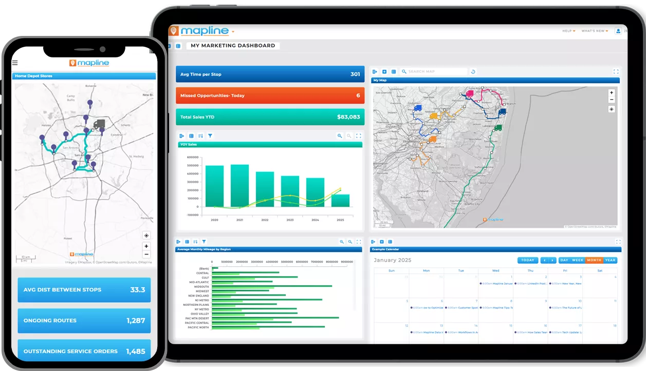
Fleet Performance Analytics

Fleet analytics powered by geospatial tools track vehicle utilization, idle times, and delivery productivity. Managers can identify underperforming routes, optimize driver assignments, and better predict maintenance needs. This ensures assets are fully utilized and operations remain cost-effective over time.

Last-Mile Analytics

Last-mile analytics uses spatial data to uncover patterns in delivery density, success rates, and failed attempts. By visualizing where inefficiencies occur, logistics teams can adjust strategies — such as adding micro-fulfillment centers or changing delivery windows. This insight ensures fewer missed deliveries and happier customers.

mapline vs tableau: best alternative to tableau

Customer Location Intelligence

Geospatial analytics enables businesses to evaluate delivery demand by region, density, and order frequency. By combining spatial data analysis with customer insights, companies can prioritize high-demand areas and reallocate resources accordingly. This not only improves efficiency but also boosts customer satisfaction by delivering faster in priority markets.

The Role of Technology in Scalable Logistics

As logistics networks grow more complex, traditional planning tools fall short. Delivery route planner free apps may provide basic functionality, but they can’t match the scale and precision required for enterprise logistics. By adopting advanced delivery route planning software, companies gain real-time visibility and the ability to adapt instantly. Mapline provides this scalability without the steep learning curve associated with legacy platforms, ensuring teams can act on insights quickly and effectively.

What is geospatial analytics in logistics?

It’s the use of geographic and spatial data to optimize delivery operations, especially last-mile performance.

How does spatial analysis software improve delivery?

It helps identify the fastest, most efficient routes while reducing costs and delivery delays.

Can free delivery route planners solve the last-mile puzzle?

Free tools are helpful but limited. Enterprise-grade delivery route planning software like Mapline provides real-time adjustments and scalability.

What is fleet analytics?

Fleet analytics tracks vehicle performance, utilization, and delivery productivity, helping logistics managers maximize efficiency.

How does last-mile analytics reduce costs?

By revealing where failed deliveries and bottlenecks occur, businesses can redesign strategies to cut waste and improve performance.

Do I need GIS expertise to use Mapline?

No. Mapline makes geo spatial analytics accessible to any business user, without complex training.

What industries benefit from geospatial logistics tools?

E-commerce, retail, food delivery, healthcare, and distribution companies all benefit from improved route planning and efficiency.

How does location-based analytics improve customer satisfaction?

It enables faster delivery times, fewer failed attempts, and more reliable service by analyzing demand by region.

SOLVE THE LAST-MILE PUZZLE WITH GEOSPATIAL ANALYTICS AND CUT DELIVERY COSTS WITH MAPLINE