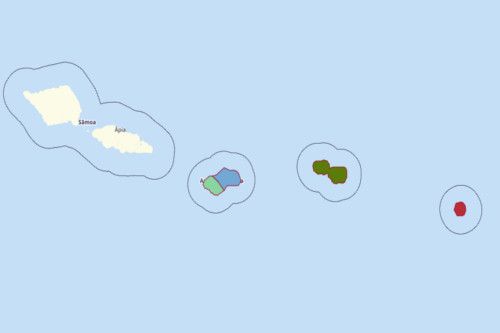
AMERICAN SAMOA COUNTIES
- Territory Guide
- AMERICAN SAMOA COUNTIES
You can easily create an American Samoa Counties map using Mapline. Located between Hawaii and New Zealand, the island of American Samoa enjoys the clear blue waters of the Pacific Ocean. As U.S. territorial control, its major economic sectors include tuna fishing and processing plants.
LEARNING MORE ABOUT AMERICAN SAMOA COUNTIES
It was in 1872 when the island felt the influence of the United States, but it was only in 1899 when the island became a US territory. Its total land area is 76.1 square miles (197.1 km2) which makes it slightly larger than Washington, D.C. The districts of American Samoa are divided into 16 counties and 74 villages.
ADD AMERICAN SAMOA COUNTIES TO MAP
Add American Samoa counties in seconds! All you need to do is to click the ADD button in the sidebar of your map. Then, select TERRITORIES from the drop-down menu and FROM MAPLINE’S REPOSITORY. Use the search bar to type AMERICAN SAMOA. Automatically, it will show you American Samoa Counties. Just click it to start adding the territory to your map.


Pro Tip: ONLY INCLUDE A PRO TIP IF THERE’S USEFUL OR VITAL INFORMATION USERS NEED TO KNOW.
CHOOSE [AREA] COLORS
Get more acquainted with different color styles. This is your color styling cheat sheet to help you decide of the different color styles to choose from – random colors, uniform color, heat map, or custom colors from spreadsheet.

GET NEW TERRITORY INSIGHTS
That’s how easy it is to create an American Samoa Counties map! Once you have your map, you can create a map of Excel spreadsheet locations to overlay on top. Mapline also makes it simple to see summary information about the locations inside each county just by clicking on them! Sign up now to create an American Samoa Counties map.


