Every year, businesses generate more data than the year before—from customer behavior and online transactions to logistics and field operations. But as datasets grow, static reports and traditional spreadsheets can’t keep up. This is where location intelligence steps in. By transforming raw numbers into geographic context, businesses can finally see how markets shift, how customers move, and where operational inefficiencies hide. In a data-heavy world, location intelligence is evolving quickly, becoming smarter, faster, and more predictive than ever before.
Why Location Intelligence Matters More Than Ever
Data volume is increasing across every industry, but insights are not increasing at the same pace. Location intelligence software closes that gap by revealing the “where” behind your operations—where sales come from, where delays occur, where opportunities cluster, and where risks emerge. As datasets grow, the ability to see patterns geographically becomes a competitive necessity rather than a nice-to-have. Modern tools combine maps, charts, geospatial analytics, and real-time data streams to make decision-making dramatically clearer.
Organizations now rely on geospatial business intelligence to understand customer behavior, evaluate performance by territory, and optimize everything from deliveries to staffing. With the rise of mobile data, IoT devices, and cloud databases, the demand for location-aware analysis is expanding exponentially. Businesses that invest in spatial analytics today are positioned to make faster, smarter, and more profitable decisions tomorrow.
Pro Tip: While traditional GIS systems can be complex, modern location intelligence platforms make geospatial analytics accessible to every team—not just data experts. The right software transforms your everyday business data into clear, actionable insight.
The Emerging Trends Transforming Location Intelligence
Location intelligence is evolving from simple mapping into a dynamic ecosystem powered by automation, predictive analytics, and cross-functional interoperability. These trends are shaping how teams visualize data, collaborate across departments, and respond to real-time events. The future is not just geographic—it’s intelligent, connected, and automated.
Predictive Spatial Analytics Becomes Standard
Instead of only showing where something has happened, modern systems predict what will happen next. Geospatial data analysis powered by machine learning can forecast shifting demand, identify emerging markets, and highlight resource needs weeks before performance metrics catch up. Businesses can simulate scenarios, test expansion plans, or anticipate disruptions—long before they hit revenue.
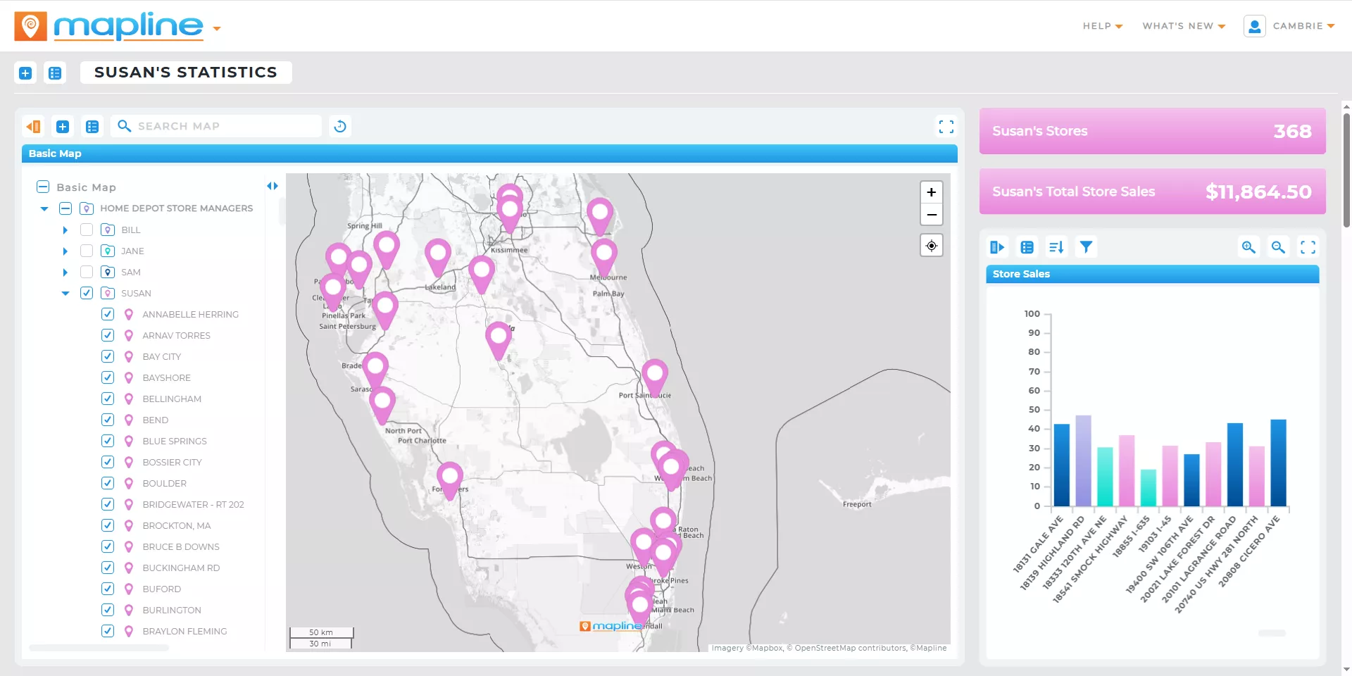
Real-Time Dashboards Replace Static Reporting
Waiting for end-of-week or month-end reports is becoming obsolete. Today, geographic information systems (GIS) connect directly to live data sources, automatically updating maps, metrics, and dashboards. This eliminates manual reporting, keeps teams aligned, and ensures leaders always have accurate information, even as conditions change throughout the day.

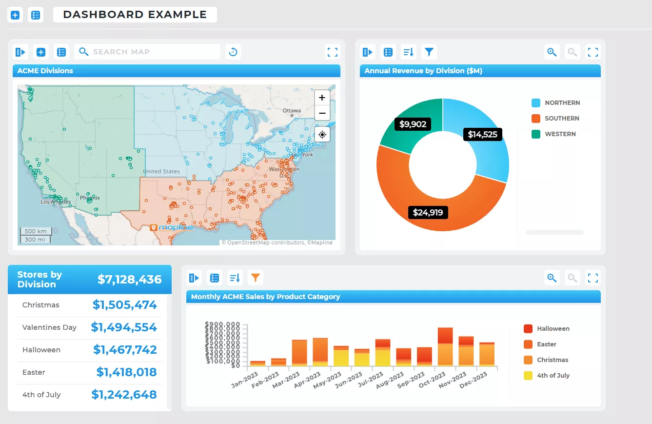
Cross-Dataset Integration Unlocks Deeper Insights
Location intelligence platforms increasingly support seamless connections across CRMs, ERPs, marketing systems, and operational tools. By merging internal and external datasets—customer locations, demographic layers, sales performance, service territories—organizations can analyze operational patterns from every angle. Integrated spatial analytics create a unified view that accelerates problem-solving and strategic planning.

Automation Reduces Operational Complexity
Advanced platforms now automate workflows such as updating territory boundaries, generating coverage maps, sending alerts, or triggering route adjustments. Instead of manually refreshing spreadsheets or redrawing regions, teams rely on automated processes to keep everything current. This frees up time, reduces errors, and improves responsiveness across large field teams or distributed operations.
How Businesses Are Using Location Intelligence to Stay Competitive
From retail to logistics to healthcare, location intelligence is helping organizations solve real operational challenges. It improves forecasting accuracy, highlights underserved markets, and shows exactly where resources need to move. Many companies leverage location intelligence software to balance territories, optimize routes, track KPIs, and identify pockets of opportunity hidden in dense datasets. When used consistently, it becomes a decision-making framework that increases profitability and reduces operational friction.
As businesses grow more data-heavy, they rely on geospatial intelligence to manage complexity. It offers leaders the clarity they need to cut costs, scale efficiently, and react faster than competitors. Simply put: organizations that use geospatial analytics will outperform those that don’t.
What the Future Holds for Location Intelligence
The next generation of location intelligence will be defined by automation, predictive forecasting, and AI-assisted decision-making. Systems will contextualize data instantly, recommend strategic actions, and power fully dynamic operations—where territories redraw themselves, routes update automatically, and dashboards refresh in real time. As maps evolve into comprehensive operational intelligence hubs, businesses will rely on them for everything from planning budgets to deploying field teams.
Ultimately, the future of location intelligence is one where data works harder, insights arrive faster, and teams operate with unmatched precision. Companies that embrace smart geospatial tools now will have a significant strategic advantage as the data landscape continues to expand.
Location intelligence is the practice of analyzing data in a geographic context—revealing patterns, relationships, and insights that spreadsheets alone can’t capture. As businesses generate more data than ever, understanding where events occur becomes essential for operational efficiency, market strategy, routing, scheduling, and customer experience. Location intelligence transforms raw data into clear, real-world insight that enables faster and more accurate decision-making.
Traditional analytics focuses on numerical trends, charts, and reports, but often ignores the spatial factors that influence performance. Location intelligence adds a geographic layer, helping teams visualize distribution, coverage, density, and distance-based relationships instantly. It closes the gap between what’s happening and where it’s happening—making analytics more actionable and contextually grounded.
As organizations collect millions of data points across customers, assets, vehicles, and regions, identifying meaningful patterns becomes harder. Location intelligence simplifies complexity by visualizing data spatially, making trends obvious without requiring advanced analysis. It allows businesses to process and understand large datasets at a glance, even when operations stretch across multiple territories or markets.
Industries with distributed operations—like logistics, field service, retail, healthcare, real estate, utilities, and manufacturing—see the biggest impact. These sectors rely heavily on travel time, territory design, asset placement, and customer distribution. However, any business with location-based data can unlock value, from sales and marketing teams to product and operations leaders.
Advancements in real-time data processing, machine learning, geo-analytics, and automated optimization are redefining how companies use spatial insight. Modern tools can now analyze movement, detect pattern shifts, predict demand spikes, and optimize routes or territories automatically. As these technologies continue to mature, location intelligence will evolve into a proactive operational engine rather than a passive reporting layer.
No. Modern platforms are built for non-technical users, allowing them to upload data, visualize insights, and run spatial analyses without specialized training. Intuitive interfaces make it easy to interpret maps, style visual layers, and explore patterns. This accessibility is a major driver behind the rapid expansion of location intelligence in everyday business operations.
Real-time data transforms static maps into live operational control centers. Instead of viewing historical patterns, teams can monitor shifting conditions—like service delays, traffic changes, regional surges, or field team activity—as they occur. This enables immediate adjustments and dramatically improves responsiveness, efficiency, and decision accuracy.
By visualizing relationships that numbers alone can’t express, location intelligence clarifies root causes faster. It highlights inefficiencies, reveals market gaps, strengthens territory alignment, and shows where operational friction occurs. Leaders gain a clearer understanding of what needs attention and why—leading to quicker, smarter decisions.
No—location intelligence enhances BI rather than replacing it. Maps and geo-analytics add spatial insight to dashboards, KPIs, and reports, creating a more complete analytical picture. Together, traditional BI and location intelligence form a powerful decision-making ecosystem.
Location intelligence will become more automated, predictive, and integrated with everyday workflows. Tools will not only visualize patterns but recommend actions, rebalance workloads, optimize routes, and adjust territories dynamically. As organizations continue to produce data at unprecedented scale, location intelligence will serve as the backbone of operational clarity and strategic agility.


