Close
WE'RE ALL ABOUT
YOUR
SUCCESS
HOW WOULD YOU LIKE TO GET IN TOUCH:
Email
Calendar
Close
READY FOR MAPLINE TO
ROCK
YOUR WORLD?
WE WANT YOU TO EXPERIENCE EVERY-THING YOU'VE BEEN MISSING BY STARTING YOUR FREE TRIAL TODAY! OUR TEAM IS READY TO HELP CHANGE YOUR LIFE. SO REACH OUT AND WE'LL GET THINGS STARTED!
Email
Calendar
Close
READY FOR MAPLINE TO
ROCK
YOUR WORLD?
Discover the potential of Mapline with a LIVE DEMO from our experts. This is your chance to see it in real-time and get all your questions answered. Connect with us to schedule your demo today!
Email
Calendar
Mapline - mapping made powerful Close
Give us a call. We'd love to talk!

+1 800.969.1454

Mapline - mapping made powerful Close
Give us a call. We'd love to talk!

+1.888.670.3795

Close
Close
Geo Mapping Starter Close

Experience the power

Get ready to see your data in a whole new way!
Geo BI Trial Close

Experience the power

Get ready to see your data in a whole new way!
Close
Close
magnifying glass with a checkmark inside

Quick Reference Guide

Save As Image

Download your maps and charts as images!

Need a sales chart for a presentation? Or maybe you want to add a heat map to your proposal? We’ve got you covered.

All map images download as PNG files. If you need another file format, a PNG can easily be converted in Photoshop, Gimp, or Canva.

SAVE

Select the area of your visualization you’d like to save. Choose from the following:

  • Map: Download only the map itself.
  • Map sidebar: Export only the sidebar of your map.
  • Chart: Download only the chart itself.
  • Legend: Export only the chart legend.
  • Chart & Legend: Export both the chart and legend.
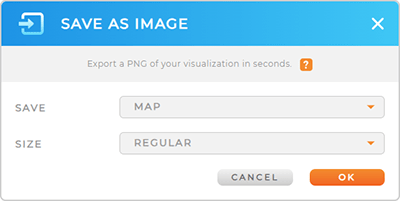
Screenshot of the Save As Image lightbox in Mapline Maps

SIZE

Set the image size you need:

  • Regular: Download an image that’s the same size as your computer screen.
  • Large: Generate an image that’s zoomed out one level further than your current screen display.
  • Extra Large: Export an image that’s zoomed out two levels further than your current screen display. This size is best for large-scale printing.
Screenshot of three maps at different zoom levels
Have questions? Want to see any of these in action?