SRI LANKA PROVINCES
- Territory Guide
- SRI LANKA PROVINCES
Understanding Sri Lanka provinces is essential for businesses looking to operate effectively across the island. A province-level map offers a high-level view of regional dynamics, helping organizations make strategic decisions that drive growth. Bring your business strategies to life within clear provincial boundaries and unlock the path to sustainable growth and lasting success. With sharp geographic insights, you’ll pinpoint high-potential markets, fine-tune resource allocation, and craft marketing campaigns that hit the mark—every time.
With Mapline, you can easily create a map of Sri Lanka provinces and start analyzing your data like never before.
WHAT ARE SRI LANKA PROVINCES?
Sri Lanka is divided into nine provinces, which encompass its 25 districts. These provinces provide a broader framework for governance, economic planning, and regional development.
Mapping Sri Lanka’s provinces allows businesses to identify growth opportunities, optimize resource distribution, and streamline logistics across regions. It’s an invaluable tool for industries ranging from retail to logistics.
ADD PROVINCES
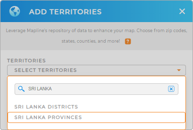
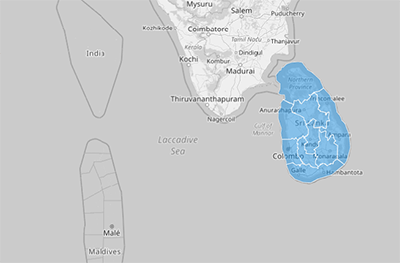
To get started, add a new territory from Mapline’s repository. Search for “Sri Lanka” and select “Sri Lanka Provinces.” Once added, you’ll have a comprehensive map showing the 9 provinces, ready for analysis and insights.
This map serves as a powerful starting point for understanding regional trends and allocating resources strategically. Imagine having the clarity to design marketing strategies that resonate on a local level


Pro Tip: Tap into Mapline’s worldwide repository of administrative and territory boundaries to learn more about your local markets and business performance! Explore related administrative boundaries, including Sri Lanka districts.
CHOOSE PROVINCE COLORS
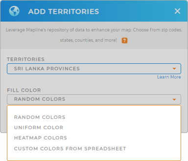
Take your map to the next level by applying color styles. Use static colors to highlight key provinces or dynamic colors to track live performance data across your regions. This customization makes it easy to interpret and share your findings.
With well-designed province maps, you can visualize trends and act on insights faster than ever.

GET NEW TERRITORY INSIGHTS
Mapline’s tools unlock powerful ways to analyze and optimize your operations. Here’s how you can make the most of your Sri Lanka province map:
- Build cost-efficient delivery zones & schedules
- Create an automated delivery confirmation system
- Optimize and streamline your vehicle management


