- Blog
- Geo Mapping
- Mapline Geo-Enriched Data: Add Instant Geographic Boundaries to Your Maps
Government and administrative boundaries are a foundational part of how businesses understand and operate across geographic regions. In Mapline, these boundaries are built directly into the platform, allowing users to instantly map, analyze, and organize data by predefined regions like states, counties, ZIP codes, and more. Instead of sourcing and importing boundary files manually, teams can access a global repository of territories and apply them to their data in just a few clicks.
This makes it easy to visualize performance, segment customers, and structure operations around real-world geographic divisions. Whether you’re building sales territories, analyzing regional performance, or planning expansion, Mapline enables you to work with accurate, ready-to-use boundaries at any scale. Combined with Mapline’s analytics and optimization tools, these boundaries become more than just map layers; they become the framework for smarter decision-making.
What Is Geo-Enriched Data?
Geo-enriched data is data that has been enhanced with additional geographic attributes to make it more meaningful and actionable. Rather than working with basic location data alone, geo-enrichment adds layers such as demographics, territory assignments, distance calculations, and routing insights. This allows businesses to better understand not just where things are, but how they relate to surrounding areas and operational factors.
By enriching data with geographic context, teams can uncover patterns that aren’t visible in spreadsheets or static reports. For example, you can evaluate customer density within specific regions, measure proximity between locations, or assign accounts to the most efficient territories. In Mapline, these enhancements happen seamlessly, enabling users to analyze, automate, and optimize their workflows without needing complex data processing or GIS expertise.
Pro Tip: Start by adding the geographic boundary that best matches how your team actually makes decisions—such as ZIP codes, counties, states, or custom regions—instead of defaulting to the broadest option. This makes your analysis more actionable from the start and helps you uncover patterns in performance, customer distribution, and market opportunity much faster. Once your boundaries are in place, you can enrich them with demographic data or layer in your own locations to turn simple map regions into powerful operational insights.
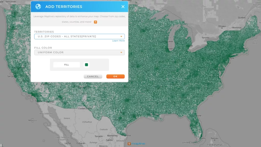
What Are Government + Administrative Boundaries?
Government and administrative boundaries are officially defined geographic areas used to organize regions for political, statistical, and operational purposes. These include familiar divisions like countries, states, provinces, counties, ZIP or postal codes, and legislative districts. They provide a standardized way to group locations, making it easier to analyze data, compare regions, and align business strategies with real-world geography.
In Mapline, these boundaries are available as ready-to-use map layers that can be applied instantly to your data. Once added, users can overlay their own locations, enrich regions with demographic data, and perform analysis at any geographic level. This allows organizations to move beyond simple mapping and into structured, scalable decision-making, whether they’re optimizing territories, evaluating performance, or identifying new market opportunities.

Geographic Boundaries
Mapline enables users to work with a variety of geographic boundary types to match their analysis needs. These boundaries represent different levels of geographic detail and can be used to overlay demographic insights directly onto maps.
United States Boundaries
Mapline provides a comprehensive set of United States boundaries, including states, counties, ZIP codes, census tracts, congressional districts, and more. These standardized regions make it easy to analyze data, build territories, and compare performance across different geographic levels. With ready-to-use boundary layers, teams can quickly apply structure to their data and make more informed, location-based decisions.
| Supported Boundary Types | |||
|---|---|---|---|
| Counties | Census Tracts | Congressional Districts | Local Divisions |
| States and Regions | Statistical Areas | ZIP / Postal Codes | Custom Territories and User-Defined Regions |
These boundaries allow users to compare performance, identify trends, and segment markets across different geographic levels.
For a full breakdown of the geographic areas available in Mapline, click here.
Canada Boundaries
Mapline supports key Canadian boundaries such as provinces, territories, and postal codes, allowing businesses to organize and analyze data across Canada. These boundaries help teams understand regional differences, plan coverage, and evaluate market opportunities. By applying these predefined regions, users can quickly segment and visualize their data without manual setup.
| Supported Canada Boundaries | ||
|---|---|---|
| Agricultural Regions | Census Divisions | Census Metropolitan Areas (CMAs) |
| Census Subdivisions | Census Tracts | Consolidated Subdivisions |
| Designated Places | Forward Sortation Areas (FSAs) | Population Centers |
| Provinces | Townships | |
Global Boundaries
Mapline is the only business mapping platform that offers global government and administrative boundaries as native, ready-to-use map layers. Users can instantly apply these regions, enrich them with their own data or Mapline’s datasets, and turn geography into actionable insights, all without importing shapefiles or relying on GIS tools. This makes it possible to analyze and optimize operations anywhere in the world from a single platform.
We offer global administrative territories, including the following boundary types in countries all over the globe:
| Global Administrative & Geographic Boundaries Supported | ||||
|---|---|---|---|---|
| Administrative Units | Agricultural Regions | Arrondissements | Block Groups | Blocks |
| Cantons | Census Tracts | Cities | Combined Statistical Areas (CSAs) | Communes |
| Congressional Districts | Countries | Counties | Departments | Districts |
| Divisions | Economic Regions | Federal District Regions | Gewogs | Governorates |
| Legislative Districts | Local Government Areas | Localities | Meso Regions | Metropolitan Divisions |
| Micro Regions | Micropolitan Statistical Areas (MSAs) | Municipalities | Native Areas | National Parks |
| Neighborhoods | Parishes | Postal Codes | Provinces | Public Use Microdata Areas (PUMAs) |
| Regional Corporations | Senate Districts | States | States and Territories | Subdivisions |
| Suburbs | Townships | Tribal Subdivisions | Voting Districts / Precincts | Villages |
| Zip Codes | … and more! | |||
That’s already an extensive range of geographic areas—but it doesn’t stop there. Mapline’s global territory repository extends far beyond these categories, offering government and administrative boundaries across countries around the world. This means you can apply the same level of geographic analysis, segmentation, and optimization whether you’re working locally, nationally, or globally.
| Supported Countries | |||||
|---|---|---|---|---|---|
| Afghanistan | Albania | Algeria | Andorra | Angola | Antigua and Barbuda |
| Argentina | Armenia | Australia | Austria | Azerbaijan | Bahamas |
| Bahrain | Bangladesh | Barbados | Belarus | Belgium | Belize |
| Benin | Bhutan | Bolivia | Bosnia and Herzegovina | Botswana | Brazil |
| Brunei | Bulgaria | Burkina Faso | Burundi | Cabo Verde | Cambodia |
| Cameroon | Canada | Central African Republic | Chad | Chile | China |
| Colombia | Comoros | Congo (Republic) | Congo (Democratic Republic) | Costa Rica | Croatia |
| Cuba | Cyprus | Czech Republic | Denmark | Djibouti | Dominica |
| United Arab Emirates | United Kingdom | United States | Uruguay | Uzbekistan | Vanuatu |
| Vatican City | Venezuela | Vietnam | Yemen | Zambia | Zimbabwe |
Click here for a full list of our worldwide government and administrative boundaries.
Check out our global territory repository to see which geographic areas are available in Mapline.
Using Your New Map Territories
Once you’ve added territory boundaries to your map, they become the foundation for how you organize, analyze, and act on your data. You can layer your locations onto these regions, segment customers by territory, and instantly visualize performance across different geographic levels. This makes it easier to spot trends, identify gaps, and understand how your business is performing in each area.
From there, territories can be used to structure operations at scale. Assign accounts to reps, balance workloads, and align teams with clearly defined regions to reduce overlap and improve coverage. Because Mapline connects territories with routing, scheduling, and analytics, your boundaries aren’t static—they actively support smarter decisions and more efficient workflows across your organization.
Data Sources
Mapline’s territory boundaries are built and maintained using proprietary data curated by our internal team of mapping and data experts. Rather than relying on third-party files that may be outdated or inconsistent, we manage and validate our own geographic datasets to ensure accuracy, consistency, and reliability across the platform.
Our team continuously monitors, updates, and refines these boundaries to reflect real-world changes, so you can trust that the data you’re working with is current and dependable. This commitment to quality allows you to focus on analysis and decision-making, without worrying about sourcing or maintaining geographic data yourself.
Turn Territory Boundaries Into Action
Territory boundaries are most valuable when they’re connected to real business outcomes. In Mapline, you can enrich territories with demographic data, performance metrics, and operational insights to better understand each region. This allows you to identify high-opportunity areas, prioritize resources, and make data-driven decisions with confidence.
- Visualize performance by territory to identify trends, gaps, and high-performing regions.
- Assign accounts, leads, or service areas to specific territories to improve coverage and accountability.
- Enrich territories with demographic data to better understand customer segments and market potential.
- Optimize routes and schedules based on territory structure to reduce travel time and increase efficiency.
- Build dashboards that track territory-level metrics in real time for better decision-making.
- Automate workflows triggered by territory conditions, such as reassigning accounts or scheduling follow-ups.
By turning geographic boundaries into actionable insights, Mapline empowers you to move away from static maps and dive right into fully-optimized, location-driven operations.


