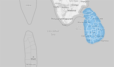
SRI LANKA DISTRICTS
- Territory Guide
- SRI LANKA DISTRICTS
A map of Sri Lanka districts holds the key to smarter business decisions and optimized operations. A district-level map provides businesses with a clear view of regional opportunities and challenges, making it easier to grow and scale. Mapline gives you the tools to build and analyze these maps in minutes, so you can focus on making data-driven decisions.
Ready to dive in? Let’s break down the process of mapping Sri Lanka’s districts.
WHAT ARE SRI LANKA DISTRICTS?
Sri Lanka, an island nation in South Asia, is divided into 25 districts across 9 provinces. Each district represents a unique blend of economic activities, cultural heritage, and geographical features.
A district-level map can help businesses identify market potential, optimize resource allocation, and streamline logistics to maximize profitability and efficiency.
ADD DISTRICTS
Start by adding a new territory from Mapline’s repository. In the search bar, type “Sri Lanka” and select “Sri Lanka Districts.” Once the districts are mapped, you’ll have a detailed visual representation of Sri Lanka’s regions to explore and analyze.
This map gives you the foundation to identify high-potential districts and streamline your business strategy across the country.


Pro Tip: Compare Sri Lanka’s districts with related administrative boundaries, like Sri Lanka provinces available in Mapline’s Repository. Get deeper insight into how different regional boundaries impact your business!
CHOOSE DISTRICT COLORS
Next, apply color styles to make your map more insightful. Static colors can highlight key territories, while dynamic colors adapt to your dataset as it updates, providing a real-time view of performance metrics or demographic data.
Well-styled maps make it easier to share insights with your team and act quickly on data-driven decisions.

GET NEW TERRITORY INSIGHTS
Mapline’s powerful features allow you to go beyond basic mapping. Here’s how you can maximize your map of Sri Lanka districts:
- Create instant customer and market maps, track sales in real-time
- Analyze your competitors and market footprints for instant laser focus
- Craft location-driven marketing campaigns and get a deeper understanding of buying behaviors


