
Mapping Albania Municipalities for Increased Situational Awareness
Uses of Municipality-Level Maps for Stronger Communication
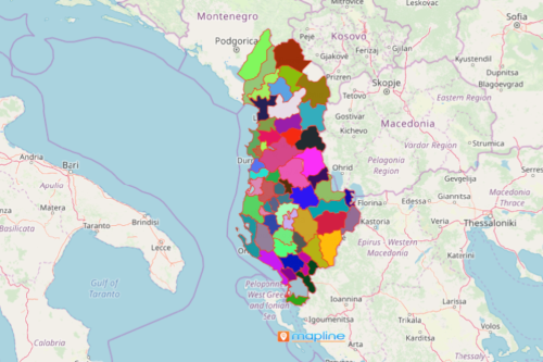
Mapping Albania municipalities is helpful for organizations for monitoring their localities. This is most relevant nowadays since the pandemic hit us and affected our lives. Knowing the geographical boundaries is a sure way to mitigate and manage risks. When you add Excel data on a municipality-based map, the actual economic situations are likely to be understood better. In addition, opportunities and needed improvements of each municipality boundary shows up when data is visualized on a map. Indeed, a map of all 61 municipalities of Albania is instrumental for each local government.
Furthermore, a territory map enables stronger collaboration and communication within agency leaders. It boosts coordination between government agencies, first responders, frontliners, and essential workers. This helps to ensure that the resources are available across all municipalities especially those that are deeply impacted by the pandemic.
Map of Albania Municipalities – A Survival Tool for Data Analysis
Create a municipality-based map to respond and operate more effectively:
- Create a Mapline account and login.
- Click the orange “Add New Items” button.
- Select “New Map” on the drop down arrow.
- Give your map a name and click “OK.”
- Click the “Add” button from the left sidebar.
- Select the “Territories” option.
- Click “From Mapline’s Repository.”
- From the “Territories” select “Albania Municipalities.” You can also enter that on the search bar.
- Select how you want your boundaries to be colored in “Fill Color” (Random Colors, Uniform Color, Dynamic heat map colors, or Custom colors from spreadsheet).
- Click “OK.”
Mapline is dedicated to help different organizations in their efforts to provide powerful data analysis and visualization to respond timely in times of crisis. Sign up now to know more about monitoring the localities and apply immediate action on risk reduction.