ISLE OF MAN PARISHES
- Territory Guide
- ISLE OF MAN PARISHES
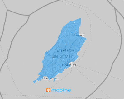
Add Isle of Man parishes to your map and get ready to amplify your analytics! Start visualizing your data within these distinct boundaries to achieve precise, location-specific insights that can transform your business operations. With a detailed view of each parish, you can instantly spot high-potential hotspots and areas that may need more focus. This valuable insight empowers you to fine-tune your strategies.
There’s so much more to it than just a line in a map! In Mapline, you can turn your territory map into a powerful visualization tool that enhances your analytics. It opens your eyes to more opportunities brimming in a competitive landscape.
WHAT ARE ISLE OF MAN PARISHES?
The Isle of Man, a captivating self-governing British Crown Dependency, is nestled in the Irish Sea between Great Britain and Ireland. Its local government structure is rooted in the island’s 17 ancient parishes, each offering a glimpse into the rich history and unique character of the region.
For businesses, parish-level analysis unlocks unparalleled insights into regional nuances, enabling you to fine-tune strategies with remarkable precision. By visualizing data on this type of territory map, you gain both detailed and holistic perspectives, empowering you to streamline planning, sharpen decision-making, and transform operations. Dive deep into the Isle of Man’s local dynamics and set your brand up for strategic success.
ADD ISLE OF MAN PARISHES
Unlock the power of a map of Isle of Man parishes today! Adding Isle of Man parishes to your Mapline map lays the groundwork for smarter decision-making and enhanced operational efficiency. Watch your business strategies soar to new heights.
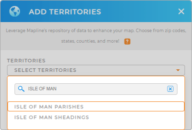
In just a few seconds, you can add a new territory from Mapline’s repository. Type ISLE OF MAN and select ISLE OF MAN PARISHES.
Now, let’s quickly move on to the last step.


Pro Tip: Access Mapline’s Repository to add Isle of Man territories to your map including parishes and sheadings. What a fantastic way to enhance your analytics!
CHOOSE PARISH COLORS
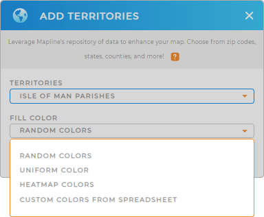
The last step is to customize your territory color styles and transform your data into a vivid narrative that aligns with your goals. Whether you’re identifying trends, tracking performance, or comparing regions, harnessing the power of color makes it easier to interpret insights at a glance and take decisive action.
Let Mapline help you choose the best color styles! Choose from random or uniform colors, custom colors, or heat map. Once you’ve made your decision, click OK to wrap up the process of adding parishes to your Ireland map.

GET NEW TERRITORY INSIGHTS
Now, level up your analytics by applying these Mapline’s powerful capabilities on your map:
- Easily generate detailed maps of customer locations
- Target potential customers when you craft hyper-targeted campaigns
- Leverage Mapline data to import vital information that helps you optimize logistics


