GERMANY DISTRICTS
- Territory Guide
- GERMANY DISTRICTS
Capture insights crucial to your business growth as you make a map of Germany districts a pivotal part of your analytic tools. A district territory map is a powerful tool for capturing and visualizing key insights at a glance. Turn it into a dynamic hub where everything comes together for seamless access and smart analysis! This approach is exceptional especially if you’re looking for ways to monitor your business operations spanning throughout the country.
Make more informed decisions as you create a Germany district map in a heartbeat!
WHAT ARE GERMANY DISTRICTS?
Germany is a country in Central Europe divided into 401 districts. Germany has the largest economy in Europe. Hence, a district-level map helps discover the essence of location in a business. It reveals insights that may be hidden from raw data. In a map with detailed district boundaries, you can pinpoint the perfect store location, where to expand, how to reach out to new markets, and how to optimize service deliveries. Bringing together customer insights, demographics, and territory boundaries unlocks the true power of strategic location planning—helping you master territory management with precision and confidence!
How awesome is that!
ADD GERMANY DISTRICTS
Creating a district territory map takes only a matter of seconds. Then, start customizing your business strategies. Seamlessly integrate the district boundaries into your map for a solid foundation leading to informed decision-making.
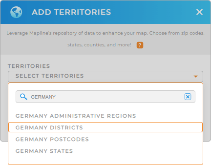
To do that, you have to add a new territory from Mapline’s repository. Type GERMANY into the search bar, and select GERMANY DISTRICTS.
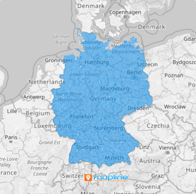
One more quick step and your map is complete.


Pro Tip: Add precise regional divisions to your map, thanks to Mapline’s extensive list of territory boundaries. Leverage it to explore boundaries in Germany including Germany administrative regions, Germany postcodes, Germany states, and districts.
CHOOSE DISTRICT COLORS
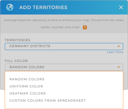
The last step is to customize your map colors. By applying color styles, you can visualize key data and trends at a glance.
Suppose you’re a business owner managing your country-wide operations. By applying territory colors based on your data, you can gain location-based insights that greatly enhance your decision-making. Imagine being empowered to analyze sales trends, identify high and low-performing districts, and make strategic decisions all at once!
Add your desired territory color styles then click OK. Now, there’s your map of Germany districts ready to be analyzed.

GET NEW TERRITORY INSIGHTS
Accelerate your business strategies as you unlock hidden insights using these powerful capabilities:
- Add a new chart to visualize snapshots of your data
- Access Mapline Data to calculate key metrics and to gain valuable insights
- Share a report with your sales team to promote collaboration


