JAPAN REGIONS
- Territory Guide
- JAPAN REGIONS
A map of Japan regions is essential for evaluating risks, identifying opportunities, exploring new markets, and understanding customers’ purchasing behaviors. Visualizing your data within these boundaries can reveal hidden patterns in data, helping you make more strategic and informed decisions. This detailed map offers valuable support for swift, effective decision-making and planning. By adding boundaries to a map, you gain a deeper understanding of how location data interacts with its borders, offering crucial insights.
Learn the easiest way to add these administrative boundaries to your map in seconds! Let’s start now!
WHAT ARE JAPAN REGIONS?
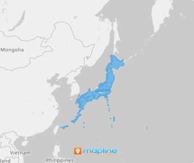
Japan’s regional division, consisting of eight regions, is primarily used for statistical purposes. Successful brands turn to Japan region maps to gain clearer insights from their data. When data analysis is enhanced with these boundaries, the patterns hidden within rows and columns of a spreadsheet become more apparent. The insights drawn from this approach are essential for informed decision-making and strategic planning.
Your journey to uncover new patterns through Japan region mapping. Let’s get you started now!
ADD JAPAN REGIONS
Add Japan regions to your map today and start harnessing insights to fine-tune your strategies, optimize resource allocation, and enhance business operations, leading to tangible, measurable results. Transform your region territory map into a rich source of spatial intelligence, providing the clarity needed to refine your insights and drive more informed decision-making.
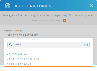
It’s so easy to add a new territory from Mapline’s repository! Just type in JAPAN in the search bar and choose JAPAN REGIONS.
One last step to successfully add these boundaries to your map.


Pro Tip: Tap into Mapline’s global repository of territories to explore broad territory options including Japan prefectures, regions, and Japan cities. This approach helps elevate your analytics and discover insights that may have previously been unseen.
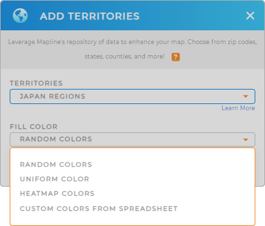
CHOOSE REGION COLORS
Now, fill your territory with colors to get clear insights. Strategically use colors to bring your business operations to life, allowing key trends and patterns to stand out. No matter which color styling you choose, the resulting insights reveal crucial location-based data that can drive smarter, more informed decisions across your logistics, operations, and marketing strategies.
Click OK when you have configured your settings and voila! You can start analyzing your map of Japan regions to get crystal-clear location-based insights.

GET NEW TERRITORY INSIGHTS
Amplify your data and territory analyses as you leverage these powerful capabilities
- Experiment with different versions of your territory map to meet the evolving demands in your business
- Access the folder report to have a full understanding of your data
- Add new locations to your map in seconds


