PANAMA DISTRICTS
- Territory Guide
- PANAMA DISTRICTS
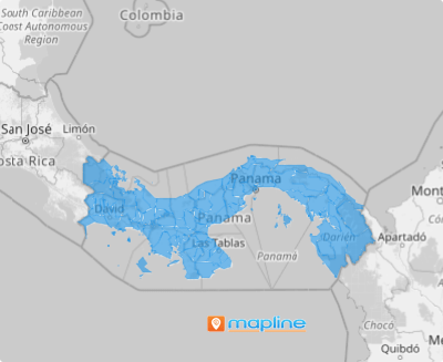
A map of Panama districts is a great tool to transform your location analytics and get insights to reshape your business strategies. By leveraging district-level analysis, you can make more informed decisions that drive business growth and build stronger customer connections. A deeper understanding of the local preferences and purchasing habits can align your products and services with customer needs. Whether you’re refining marketing tactics, optimizing logistics, or strengthening customer engagement, this approach enables you to connect the dots where it matters most, driving success where it counts.
Got 60 seconds? We’ll walk you through a district territory map creation process starting right now!
WHAT ARE PANAMA DISTRICTS?
Panama, located at the southern end of Central America, is home to a diverse range of districts across its provinces and comarcas. Notably, over 50% of the country’s population resides in the districts of Panama, San Miguelito, Arraijan, Chorrera, and Colon. Understanding this distribution is key to crafting hyper-local strategies that resonate with the needs of your target audience, ensuring that your approach is relevant and impactful in each specific region.
Let’s get you started with your Panama district map creation. It’s not just a map—it’s your key to understanding your audience and unlocking new growth opportunities!
ADD PANAMA DISTRICTS
Empower your business with a map of Panama’s districts! Gain valuable insights into customer demographics and craft strategies that hit the bullseye with your target market.
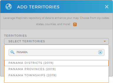
Mapline makes it easy for you to add a new territory from Mapline’s repository. Just type PANAMA in the search bar and choose PANAMA DISTRICTS from the selections.


Pro Tip: Mapline’s repository empowers you to add regions from different countries to your map in more detailed data and territory analyses. That includes Panama boundaries like Panama provinces, Panama districts, and Panama townships.
CHOOSE DISTRICT COLORS
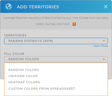
Bring your data to life with a vibrant map of Panama’s district boundaries! Adding the right colors to your map uncovers insights often buried in spreadsheet rows and columns. A thoughtfully chosen color style transforms your territory map into a powerful tool for strategic planning, making complex data easy to interpret.
Choose the right color styles that don’t just enhance visuals—they amplify your understanding. Once you’re done selecting the type of territory colors, click OK.

GET NEW TERRITORY INSIGHTS
With your map of Panama districts in tow, you can do so much more to improve your analytics when you leverage these powerhouse capabilities:
- Pull your spreadsheet data directly into Mapline with Google Sheets connector
- Analyze your customers in minutes rather than days or weeks when you create instant customer and market maps
- View territory report to extract valuable information in a flash


