PARAGUAY REGIONS
- Territory Guide
- PARAGUAY REGIONS
Harness the transformative potential of a detailed map of Paraguay regions to sculpt customized strategies that resonate with local markets. Many brands utilize a region-level analysis, empowering them to design marketing campaigns that target the needs of their customers.
Here in Mapline, we’ll take you on a quick ride of region mapping to help elevate your marketing efforts as you understand the complexities of the market with precision. Align your strategies with the distinct attributes of each region to create compelling campaigns that truly resonate, ensuring your brand stands out in a competitive landscape. And the best part of this mapping journey is that it will only take you less than a minute!
WHAT ARE PARAGUAY REGIONS?
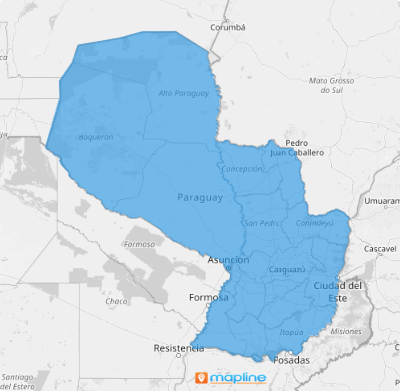
Mapping Paraguay’s regions is a tremendous help for understanding and enhancing community dynamics. As a landlocked nation in South America, Paraguay is divided into departments, which are further categorized into two major regions: the Western region, known as Gran Chaco, and the Eastern region, referred to as Paraguay Proper. Successful brands rely on a detailed region map to monitor the unique characteristics and needs of each area. This map highlights the opportunities present in each region, providing invaluable insights for business development planning.
Utilize a map of Paraguay regions and gain a comprehensive view of what is transpiring across various locales! Derive hyper-local insights from this mapping to craft strategies for more effective sales and marketing, and customer connection.
ADD PARAGUAY REGIONS
Make your region territory map a solid foundation for informed decision-making once you integrate region boundaries into your map. With a distinct visual representation of your data, you can start identifying trends and patterns specific to each region.
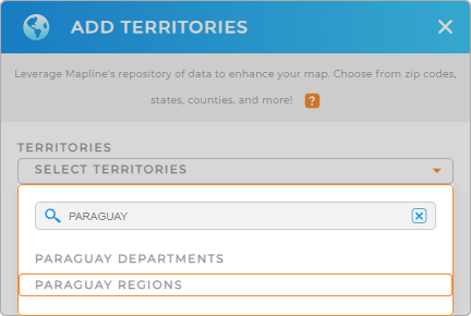
It’s so easy to do that, you just need to add a new territory from Mapline’s repository, type PARAGUAY into the search bar, and select PARAGUAY REGIONS.
With the right territory added, you’re just one step away from creating the most powerful visualization that will allow you to gain location-based insights for effective marketing strategies and boost overall sales performance.


Pro Tip: Leverage Mapline’s Territory Repository to speed up your analysis. It houses worldwide territory boundaries, including Paraguay departments and regions. Go ahead and add them to your map now to gain sharper insights for informed decision-making.
CHOOSE REGION COLORS
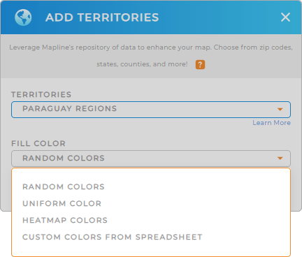
The last step is to choose the fill colors for your territory map. Colors help create a more powerful visualization to extract meaningful insights at a glance. This capability can significantly enhance your business operations.
To achieve the right territory color styling, Mapline provides brilliant selections – heat map colors, custom colors, random colors, and uniform color. Choose the best selection suitable to your type of analysis. Lastly, click OK.
Now you’ve just enhanced the power of your map of Paraguay regions big time!

GET NEW TERRITORY INSIGHTS
Leverage Mapline’s powerful capabilities when analyzing your data on a map of Paraguay regions:
- Plot competitor locations to make competitor analysis
- Run data calculations and achieve actionable insights from your territory data
- Get real-time snapshots of your operations with business intelligence


