SLOVAKIA REGIONS
- Territory Guide
- SLOVAKIA REGIONS
Add Slovakia regions to your map and unleash the full potential of region-level insights! With a detailed region territory map, you can dive deep into the factors shaping your business landscape. Conduct comprehensive competitor analysis, identify opportunities to outpace rivals, and bolster your sales and marketing strategies.
It’s quick and effortless to set up—giving you powerful results in no time. This small step could be the game-changer your business needs to soar to new heights!
WHAT ARE SLOVAKIA REGIONS?
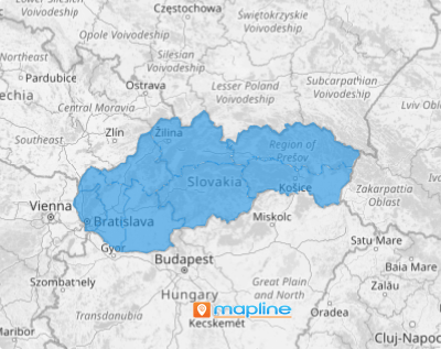
Slovakia, nestled in the heart of Central Europe, is a landlocked gem divided into eight distinct regions. Since 2002, these regions have flourished with a newfound autonomy, governed by Self-governing Regions or Upper-Tier Territorial Units.
A detailed region map can be a game-changer, empowering you to make strategic decisions that drive growth and elevate your business to new heights. Let’s say you’re a sales manager wanting to have a full view of your competitive landscape. This map brings a picture into sharp focus. Picture seeing exactly where your competitors are positioned and their proximity to your business! This detailed view reveals the intricate dynamics of your market share compared to your rivals. How awesome is that!
ADD SLOVAKIA REGIONS
Capture data insights in real-time as patterns and trends emerge, soaring through the intricacies of region boundaries. Unlock the power of localized information and watch as key trends unfold before your eyes, guiding your business to smarter, faster decisions.
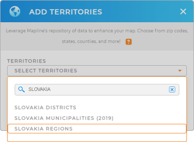
To do that, first, add a new territory from Mapline’s repository. Then utilize the search bar to type SLOVAKIA and select SLOVAKIA REGIONS from the selections.
And that’s how you add territories to your map!


Pro Tip: Mapline’s territory repository offers a comprehensive collection of predefined territorial boundaries for Slovakia, including Slovakia districts, Slovakia municipalities, and regions. This extensive database enables you to enhance your maps with precise geographic data, facilitating strategic decision-making, targeted marketing, and optimized logistics.
CHOOSE REGIONS COLORS
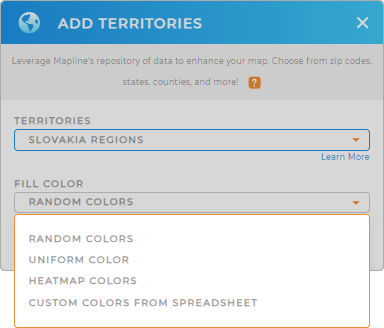
Now that you have selected the right territory, it’s time to apply a fill color. Territory colors are a powerful tool for spotting spatial patterns, trends, and concentrations within your territories. By highlighting key areas with distinct colors, you can quickly identify regions of opportunity, track performance, and uncover hidden insights that drive smarter decisions.
Choose static colors for an engaging, easy-to-understand map, perfect for showcasing territory assignments to sales teams. For a deeper level of insight, choose dynamic colors to visualize your data, making it easy to spot growth opportunities at a glance. The best color styles transforms your data into a visually clear and impactful presentation, driving data-driven decisions. Get ready to turn complex data into actionable insights in just moments!

GET NEW TERRITORY INSIGHTS
Extract more insights for business growth by applying these powerful capabilities to your analysis:
- Take the guesswork out of optimized vehicle management
- Draw custom territories tailored to your specific requirements
- Perform advanced calculations for enhanced territory insights


