SLOVENIA REGIONS
- Territory Guide
- SLOVENIA REGIONS
Stay ahead of the competition by incorporating a territory map of Slovenia’s regions into your analysis. Visualizing these region boundaries gives you a strategic edge, allowing you to optimize your logistics and supply chain operations with precision. Imagine having the ability to map out the most efficient routes, pinpoint ideal locations for distribution centers, and define the most effective delivery zones—all tailored to the unique landscape of each region. This kind of insight empowers you to streamline your operations, reduce costs, and enhance your overall business efficiency.
With a map of Slovenia’s regions at your fingertips, you’re not just planning—you’re strategically positioning your business for success. Let’s start adding these region boundaries to your map now!
WHAT ARE SLOVENIA REGIONS?
The 12 statistical regions of Slovenia were established in 2000 for both legal and statistical purposes. Crafting a regional territory map of Slovenia can substantially boost your competitive edge by providing a detailed view of regional dynamics and trends. By utilizing this map, you gain invaluable insights into how to optimize your service deliveries, tailor your strategies to regional characteristics, and make data-driven decisions that keep you ahead of the curve.
Be pleasantly surprised to discover that creating a map of Slovenia’s regions is simpler than you might think. Follow these two easy steps, and you’ll have a powerful tool at your disposal to enhance your operational efficiency and strategic planning.
ADD SLOVENIA REGIONS
With a clear visualization of region boundaries, you can identify the different opportunities impacting your logistics and supply chain operations. Imagine effortlessly seeing the optimal locations for warehouses and distribution centers based on proximity to key customer areas and transportation hubs.
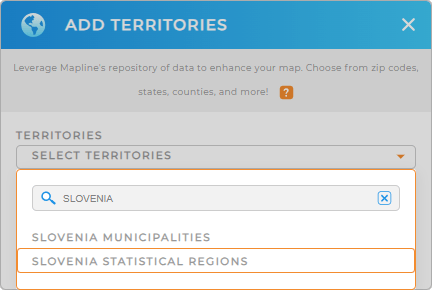
To do that, first, add a new territory from Mapline’s repository. In the search bar, type SLOVENIA and select SLOVENIA REGIONS.
We’re halfway there. Now, let’s take you to Step 2.


Pro Tip: You can add Slovenia municipalities and regions easily on your Mapline map. Both options are available in Mapline’s Territory Repository. This innovative approach to powerful visualization allows you to identify critical resource gaps, discover hidden patterns, and streamline your business operations like never before!
CHOOSE REGION COLORS
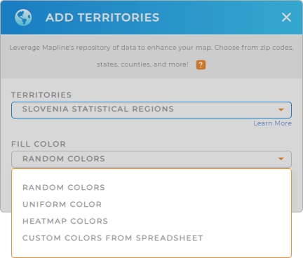
Step 2 is all about choosing the fill color for your territory. Colors applied to your map add to a more powerful visualization. At a glance, you can extract value that can be used to enhance logistics and supply chain operations. Apply custom colors to regions based on average delivery time. Or use predefined colors for territories assigned to different sales reps. You can also apply heat map colors to generate a stunning representation of data density around your pins.
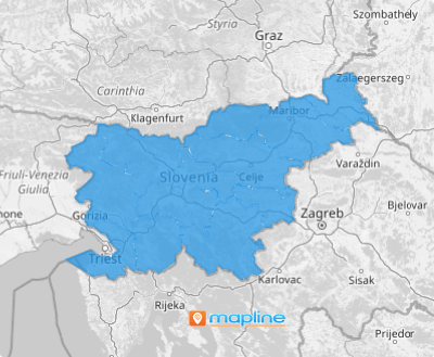
Once you have configured your color styles, click OK and your map of Slovenia regions is ready to be viewed and analyzed.

GET NEW TERRITORY INSIGHTS
Take advantage of these capabilities for added aid to identify more insights to enhance your logistics operation:
- Draw custom shapes to get the exact borders you need
- Automate trip planning to manage your sales reps’ performances more efficiently
- Access the folder report to give you a snapshot of the information within your map layer


