URUGUAY DEPARTMENTS
- Territory Guide
- URUGUAY DEPARTMENTS
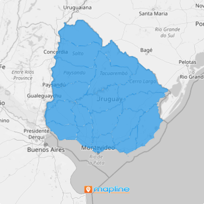
Stay one step ahead of the competition when you create a territory map of Uruguay departments. These department boundaries provide a visually broader scope to analyze which customers fall within the territory and which competitors you should watch out for. A clear visualization of department boundaries transforms your logistics and supply chain strategy—helping you effortlessly pinpoint the perfect spots for warehouses and distribution centers, right where your customers and transport links align.
With powerful insights at your fingertips, you’ll elevate your logistics strategy—streamlining operations, cutting costs, and delivering with precision like never before. Start assessing factors that affect your business as you learn to create this territory map in a flash!
WHAT ARE URUGUAY DEPARTMENTS?
Uruguay is located in South America. Department boundaries, or departmentos, are the foundation of the country’s administrative divisions. These departments each have an Intendant, or Governor, who remains in office for five years and oversees the public businesses in their department. Uruguay is divided into 19 departments – all presenting opportunities for market expansion and enhancing the way you do your business.
Elevate your A-game with a deeper understanding of the strenths of each department and enhanced market strategy development. Here’s how to quickly add Uruguay departments to your map.
ADD URUGUAY DEPARTMENTS
Mapline makes it easy to add a new territory from Mapline’s repository. You can do it in 60 seconds or less!
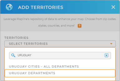
With the ADD TERRITORIES window open, type URUGUAY into the searchbar and select URUGUAY DEPARTMENTS. (No need to scroll through the entire list– the searchbar helps you find exaclty what you need, right away).
With a clear visualization of department boundaries, you can identify the different opportunities impacting your competitive landscape.


Pro Tip: You can add either Uruguay departments or Uruguay cities to your map in seconds! Both options are available in Mapline’s Repository. Add these boundaries to your map and watch hidden patterns come to life—revealing key insights that fuel smarter, more strategic business planning.
CHOOSE DEPARTMENT COLORS
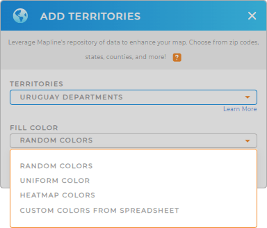
Make your map more visually impactful and functional by selecting your preferred color styling.
This simple step makes it facilitates deeper analysis, so you can get key insights from your map at a glance. Custom colors help you discover important trends in your territory so you can act quickly and stay ahead of the competition.
Just select the best color style for your analysis—random, uniform, custom-color, or heat map—then click OK. It’s that easy!

GET NEW TERRITORY INSIGHTS
Finally, let’s enhance your department territory map with these powerful capabilities:
- Draw custom territories for clearer analysis of your business operations
- Perform advanced data calculations with Mapline Data
- Customize charts to visualize key metrics and fine-tune your strategies for maximum impact


