ARGENTINA PARTIDOS- BUENOS AIRES PROVINCE
- Territory Guide
- ARGENTINA PARTIDOS- BUENOS AIRES PROVINCE
Unlock valuable regional insights by mapping Argentinas partidos in Buenos Aires Province with Mapline. Mapping these administrative boundaries enables brands to streamline logistics, optimize territory management, and deepen customer engagement strategies. For companies involved in sales, service delivery, or regional operations, partidos in Buenos Aires Province offer a granular view of population distribution, market demand, and service coverage. By visualizing data at the partido level, your team gains the local insights needed for strategic, data-driven decision-making.
Let’s explore how mapping Buenos Aires Province’s partidos can help your business gain an edge in regional planning and customer engagement.
WHAT ARE ARGENTINA PARTIDOS?
In Argentina, partidos are administrative divisions within provinces, similar to counties in other countries. Buenos Aires Province is divided into partidos, each responsible for governing a specific area and providing essential services. Each partido has unique demographic and economic characteristics, making them valuable for businesses looking to customize marketing, optimize service delivery, or refine logistics in specific regions. For brands operating in logistics, sales, or operations, mapping these partidos allows for a targeted approach to market analysis, customer segmentation, and regional strategy.
Mapping Buenos Aires Province’s partidos empowers brands with a localized understanding, supporting more effective, data-backed decisions that align with regional needs.
ADD PARTIDOS TO MAP
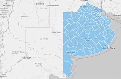
Adding Buenos Aires Province’s partidos to your Mapline map creates a foundation for tracking performance, planning efficient routes, and managing customer engagement across specific areas. This partido-level setup supports targeted planning and resource allocation tailored to each region’s unique profile.
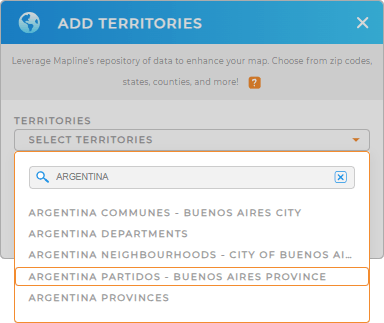
To get started, add a new territory from Mapline’s repository, type ARGENTINA in the search bar, and select ARGENTINA PARTIDOS – BUENOS AIRES PROVINCE from the dropdown.
Now, your map is ready to deliver regional insights for effective decision-making.


Pro Tip: Mapline’s global territory repository includes comprehensive boundary data worldwide, helping brands manage and analyze data across multiple regions. Accessing detailed administrative boundaries like partidos supports efficient territory management and market planning. Browse our territory repository to find additional boundaries including Argentina communes, Buenos Aires City Neighborhoods, or Argentina Provinces, that match your business goals and enhance your mapping insights.
CHOOSE PARTIDO COLORS
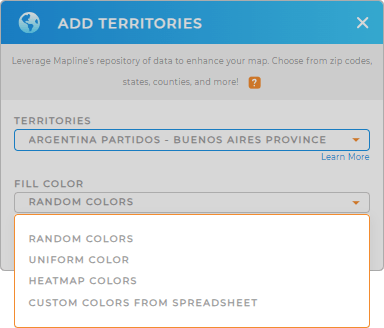
Applying colors to Buenos Aires Province’s partidos on your map is an excellent way to visualize data trends, helping you identify key markets, evaluate performance, and prioritize resources effectively. Color-coded partidos make it easy to interpret data and identify patterns at a glance, aiding data-backed decisions.
To apply color styling, select your preferred color styles to highlight important data and bring your partido-level insights into focus.

GET NEW TERRITORY INSIGHTS
Enhance your Buenos Aires Province partido map with Mapline’s advanced tools and insights:
- Use coverage areas to assess service reach and pinpoint areas for expansion
- Skyrocket your ROI as you instantly visualize trends and patterns of your customer base
- View territory reports to extract valuable insights for informed decisions


