TOGO REGIONS
- Territory Guide
- TOGO REGIONS
Cut down your time spent on territory analysis and management by analyzing your data on a map of Togo regions! Region-level mapping is a favorite among brands for its ability to deliver granular insights into local dynamics, empowering businesses to customize strategies for specific areas. Understand the geographic nuances of each region and you can customize your strategies to resonate with your audience on a deeper level. This approach not only helps you meet their unique needs but also fosters stronger connections, driving more meaningful engagement and long-lasting loyalty.
Got a minute? Well, it won’t even take that long! In just a few seconds, you’ll have a powerful visual that uncovers trends and patterns, helping you quickly make data-driven decisions.
WHAT ARE TOGO REGIONS?
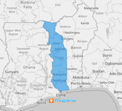
Togo, a small and tropical country in West Africa, is a sub-Saharan gem with a rich cultural heritage. It is divided into five regions, which serve as the first-level administrative divisions of the country. While regional governments handle certain local affairs, much of the power is shared with the national government, creating a balanced system of governance. This structure helps Togo navigate its development while maintaining connections between local needs and national priorities.
Map your data across regions, and watch your business uncover hidden trends, analyze powerful patterns, and gain insights that give you an edge over the competition. This strategy isn’t just about keeping up with the industry—it’s about setting the pace, driving your business forward, and carving out your path to success! Ready to take charge? Let’s map it out!
ADD TOGO REGIONS
Turn your map of Togo regions into your ultimate toolkit for business success! Dive into the region-level insights and start exploring trends and data context that can streamline your business operations like never before.
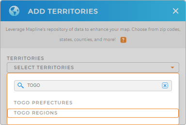
Let’s add a new territory from Mapline’s repository to your map and see how fast you can unlock the potential! In the search bar, type TOGO and click on TOGO REGIONS to add to your map.
Let’s get going!


Pro Tip: Mapline’s territory repository offers detailed boundaries for Togo, including regions and Togo prefectures, unlocking a world of insights. Dive deep into local dynamics and gain valuable intelligence for strategic planning.
CHOOSE REGION COLORS
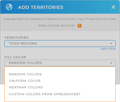
Ready to transform your analysis? Then, let’s add colors! Colors are a powerful tool that can significantly enhance your ability to interpret data and easily adjust your business strategies. By strategically applying colors to your map, you can highlight key data points, reveal emerging trends, and gain deeper insights that directly impact your business.
Dive deeper and make your map work harder for you. Choose the best color styles based on your analysis needs. Whether you prefer random colors, a uniform color scheme, heat map colors, or custom shades, you can visualize your data exactly the way you need.

GET NEW TERRITORY INSIGHTS
Be ready to gather more insights the moment you utilize these powerful capabilities when analyzing your data on your region map:
- Add a new dataset using connectors to easily manage your imports
- Never stress about missed deliveries when you design last-minute routes
- Set up a data-powered calendar and do away with manual edits and missed changes


