RWANDA PROVINCES
- Territory Guide
- RWANDA PROVINCES
Integrate a map of Rwanda provinces into your analytics to unlock a treasure trove of location insights. This powerful map visualization reveals the narratives hidden, making it effortless to identify regional patterns and emerging trends. With these newfound insights at your fingertips, you can craft strategic plans that drive business growth and pave the way for lasting success. Most successful brands use this type of territory map as their analytical go-to for strategic planning.
The best thing about utilizing this province map is that it’s so easy to create – you only need a few seconds! Then, go ahead and start your analysis to fully understand all the factors affecting your brand presence across all provinces in Rwanda.
WHAT ARE RWANDA PROVINCES?
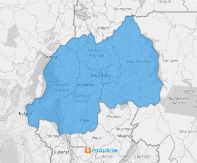
Rwanda, nestled in the heart of East Africa’s Great Rift Valley, is where the African Great Lakes region meets Southeast Africa. Just a few degrees south of the Equator, this landlocked gem rises high above sea level, earning its poetic nickname: the “Land of a Thousand Hills.” Its five provinces—Northern, Southern, Eastern, and Western, with the vibrant Municipality of Kigali at its center—have served as crucial links between the national government and local districts, ensuring that policies and initiatives reach every corner of the country efficiently.
A detailed analysis of a map of Rwanda provinces unlocks a deeper understanding of local demand patterns. Imagine having the power to offer products and services that are perfectly tailored to the unique needs of each province!
ADD RWANDA PROVINCES
When it comes to data analytics, mapping Rwanda provinces lets you see the connections of your data within the detailed province boundaries so you can make tough decisions that enhance your business planning. By analyzing data at the province level, you get a wider view of the market, allowing you to craft strategies that hit the target every time.
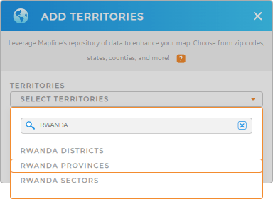
First, add a new territory from Mapline’s Repository. Type RWANDA in the search bar to select RWANDA PROVINCES and add it to your map instantly.
With the right territory added to your map, what’s next?


Pro Tip: Mapline’s Repository is available to unlock powerful new insights. Add precise Rwanda regional boundaries to your map including Rwanda provinces, Rwanda districts, and Rwanda sectors for enhanced territory planning and management.
CHOOSE PROVINCE COLORS
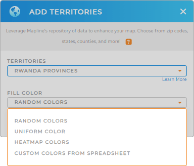
Next, let’s discover the value of a color-coded map. Colors are a great analytical tool that turns data complexity into clarity. This enhancement do more than enrich your understanding of the landscape. It helps you organize your data to get a fresh perspective for sharper analysis and visionary planning.
Choose the right type of colors to transform your data into a captivating narrative. Once you configured your settings, click OK. Now, be empowered by your map of Rwanda provinces to make important data-driven decisions.

GET NEW TERRITORY INSIGHTS
Bring your A-Game into your analytics as you apply these powerful capabilities:
- Create smart sales routes in seconds
- Display crucial information into your client locations with a single click
- Run data analytics to uncover regional trends and opportunities unique to different sectors in Rwanda


