PAPUA NEW GUINEA REGIONS
- Territory Guide
- PAPUA NEW GUINEA REGIONS
Stay ahead of the competition with a territory map of Papua New Guinea regions! Visualizing unique market dynamics at play on regional boundaries empowers you to streamline logistics and optimize your business operations like never before. Imagine effortlessly mapping routes, pinpointing ideal locations for distribution centers, and defining delivery zones with precision. Unlock the potential of region-level analysis to build an efficient logistics network that cuts costs, speeds up deliveries, and elevates customer satisfaction.
The future of smarter logistics starts here—start mapping your success today!
WHAT ARE PAPUA NEW GUINEA REGIONS?
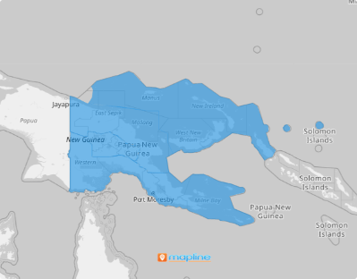
Papua New Guinea, situated in Oceania, encompasses the eastern half of the island of New Guinea and its offshore islands in Melanesia. The nation is divided into four broad regions. While not its primary administrative divisions, they play a crucial role in many facets of life, such as government operations, business strategies, sports, and political activities. Understanding these regions is essential for effectively navigating the country’s unique complexities and dynamics.
Customize your approach to address the unique needs of each target market at the region level to position your brand as a leader in an increasingly competitive landscape and create meaningful connections with your audience. You’ll be surprised to learn that you can create a map of Papua New Guinea regions by following 2 easy steps.
ADD PAPUA NEW GUINEA REGIONS
Unlock a world of opportunities for enhancing your business operations when you have a clear visualization of your region within region boundaries. With this level of insight, you can streamline operations, improve efficiency, and drive smarter, more impactful decisions for your business.
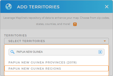
The first step is to add a new territory from Mapline’s repository quickly. Type PAPUA NEW GUINEA in the search bar to trim down the selections. Then, click to add PAPUA NEW GUINEA REGIONS to your map.
How convenient is that?


Pro Tip: Access Mapline’s global territory repository to add hundreds of boundaries to your map including Papua New Guinea provinces and regions. Analyze key metrics to gain fresh insights to help chart your course to success.
CHOOSE REGION COLORS
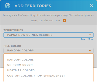
Step 2 is to choose the best fill colors for your territory map to unlock a whole new level of visualization power. Colors don’t just make your map visually appealing—they turn it into an actionable tool for insight. At a glance, you can uncover patterns to optimize logistics and supply chain operations.
Customize your regions with color styles that reflect your level of analysis. You can apply predefined colors for territories managed by different sales reps, or create eye-catching heat maps to visualize data density around your pins.
Once you’ve configured your color styles, click OK, and your map of Papua New Guinea’s regions will be ready to analyze.

GET NEW TERRITORY INSIGHTS
Now, take advantage of the following capabilities for added support to identify more location insights to enhance your operations:
- Configure dynamic pin colors to ensure your maps are always up to date
- Reach the right customers with the right message to help skyrocket your RO
- Filter active customer status to focus more on the most promising opportunities


