PANAMA PROVINCES
- Territory Guide
- PANAMA PROVINCES
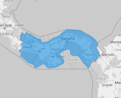
A map of Panama provinces gives you the power to dive deep into the specifics of each province, turning a clear, dynamic view of each region into actionable insights that propel your strategy forward. With a provincial-level analysis, your decision-making can be precise, powerful, and impactful. Explore how this approach can elevate your operations, streamline logistics, and supercharge your marketing strategies to reach new heights!
Whether you’re assessing market saturation, uncovering growth opportunities, or fine-tuning market strategies, Mapline’s territory mapping keeps you informed and proactive, ensuring you stay ahead in today’s competitive business environment. Start creating your Panama province map today!
WHAT ARE PANAMA PROVINCES?
Panama, a vibrant country at the crossroads of Central and South America, is organized into 10 provinces. Each province thrives under the leadership of its local authorities, known as governors, ensuring regional governance and development.
Brands operating in Panama are unlocking the power of Panama provinces mapping to gain a more detailed view of their customers and target market. Zooming in on these boundaries is a game-changer for businesses aiming to penetrate and expand within specific regional markets. If your goal is to sharpen market focus and accelerate growth, integrating province boundaries into your map is the strategic edge you need.
ADD PANAMA PROVINCES
Let’s add this territory to your map in under a minute. By adding province boundaries, you unlock invaluable insights into sales data, store risks, and competitive landscapes—all with just a few simple steps.
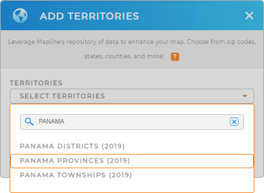
First, add a new territory from Mapline’s repository. Use the search bar and type PANAMA then select PANAMA PROVINCES.
Woah, that’s almost at lightning speed!


Pro Tip: Mapline’s worldwide territory repository empowers you to add territory boundaries from Panama including Panama districts, Panama provinces, and Panama townships to your map to achieve a more detailed data and territory analyses.
CHOOSE PROVINCE COLORS
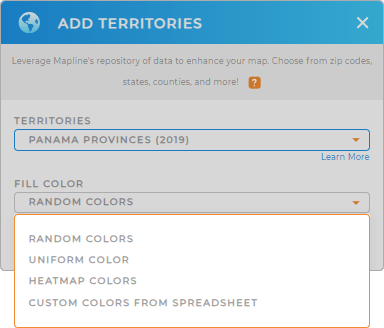
Take your data game to new heights by applying colors to your map. Colors spark insights that otherwise be left unnoticed. Say goodbye to spending hours—or even days—analyzing. Now, you can pinpoint key factors in your territories in just minutes or seconds, making your decision-making faster and more efficient than ever!
Choose the color styling that perfectly fits your type of analysis. Configure your settings, then click OK.
Now get ready to gather valuable insights as you start analyzing your map of Panama provinces.

GET NEW TERRITORY INSIGHTS
Get more actionable insights from your map when you leverage these added capabilities to your analysis:
- Style your map pins to convey crucial information
- Add text labels for clarity
- Understand data density on your map


