U.K. POSTCODE DISTRICTS
- Territory Guide
- U.K. POSTCODE DISTRICTS
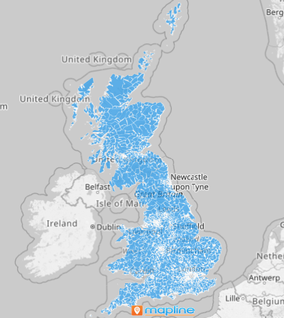
Add U.K. Postcode Districts to your map and revolutionize your territory management strategies! From crafting targeted marketing campaigns to optimizing delivery routes and discovering new growth zones, this flexible territory map is your edge.
A map of U.K. Postcode districts is more than a visual—it’s your business intelligence powerhouse. Imagine your sales ops team analyzing customer distribution across postcode districts, tailoring marketing campaigns to specific regions for maximum engagement and conversion. That’s just one example of how adding U.K. Postcode Districts to your map can drive tangible improvements in operational efficiency and effectiveness. Transform information into action—and let your map lead the way to smarter success.
WHAT ARE U.K. POSTCODE DISTRICTS?
U.K. Postcode Districts are territorial divisions used to designate specific geographic areas within the United Kingdom. For instance, a logistics company can utilize this boundary to streamline delivery routes across multiple districts, optimizing efficiency and reducing operational costs. Similarly, a marketing team can analyze customer demographics within each district to tailor their promotional campaigns effectively. Let’s dive in to how it works!
ADD U.K. POSTCODE DISTRICTS
Unlock the full potential of your maps with U.K. Postcode Districts! This powerful approach lets you explore the spatial distribution of your information with pinpoint accuracy—revealing regional trends and patterns that spark smarter, more strategic decisions.
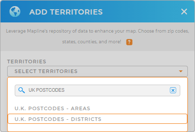
To get started, add a new territory from Mapline’s Repository, type UK in the search bar, and select U.K. POSTCODES – DISTRICTS from the menu. It’s that easy!


Pro Tip: Postcode districts are also called outward codes . Explore additional U.K. territories available in Mapline’s repository, such as U.K. Postcode Areas, London Wards, and London Boroughs, to enhance your analysis even further.
CHOOSE POSTCODE DISTRICT COLORS
Enhance the visual clarity of your map by customizing the colors of your U.K. Postcode Districts. Whether you’re highlighting regional performance metrics or visualizing customer demographics, choosing the right color scheme can help you uncover valuable insights at a glance.
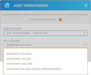
Simply select your preferred color styles – random, uniform, custom color from a spreadsheet, or heat map colors – and you’re good to go!

GET NEW TERRITORY INSIGHTS
Gear up for a more successful territory management as you apply these options:
- Segment customer data for deeper insights
- Customize your dashboard so that trend visualization is just a glance away
- Enjoy cluster mapping to reveal the relationships of data in their proximity to each other


