CZECH REPUBLIC OBLASTS
- Territory Guide
- CZECH REPUBLIC OBLASTS
A map of Czech Republic oblasts is a great tool for a laser-focus analysis of your business operations across the country. Leverage this map with in-depth oblast territory details to supercharge your analysis and drive business growth through actionable, geography-driven insights. By visualizing these detailed boundaries, you’ll unlock targeted opportunities for improvement, streamline operations, and fuel strategic decision-making to propel your business forward. Embrace this strategic edge to drive growth and connect with customers more effectively in every oblast!
Track regional performance using this oblast map and get ready to spot key areas for operational improvements and maximize your productivity to increase your bottom line! Here’s how to get started.
WHAT ARE CZECH REPUBLIC OBLASTS?
The Czech Republic, also known as Czechia—and historically as Bohemia—is a landlocked country in Central Europe, divided into eight administrative units called oblasts. Visualizing overall business performance at the oblast level is a strategic move for businesses operating across multiple districts. This localized approach allows brands to tailor their strategies, effectively meet regional demands, and precisely unlock targeted growth opportunities.
For example, you might discover that the Central Bohemian oblast serves as an economic and industrial hub. With this insight, you can refine your approach and tailor your efforts to key economic centers, ensuring your brand is positioned for maximum impact and growth. Let’s dive into adding these regions to your map, shall we?
ADD CZECH REPUBLIC OBLASTS
An oblast-level map of the Czech Republic can be a game-changer for your business strategies, providing a competitive edge through deeper insight into unique markets. This detailed mapping allows you to analyze customer preferences and behaviors more accurately, leading to informed decisions that resonate with customer expectations. Strengthen your presence in a dynamic and competitive environment by visualizing market trends, refining engagement strategies, and optimizing performance.
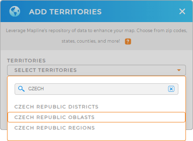
To get started, add a new territory from Mapline’s repository, type CZECH into the search bar to trim down the selections, and select CZECH REPUBLIC OBLASTS.


Pro Tip: Explore the versatility of Mapline’s territory repository by adding different territories from the Czech Republic including Czech Republic districts, Czech Republic regions, and oblasts to your map. Incorporate these territories and unlock laser-focused insights tailored to your specific business needs.
CHOOSE OBLAST COLORS
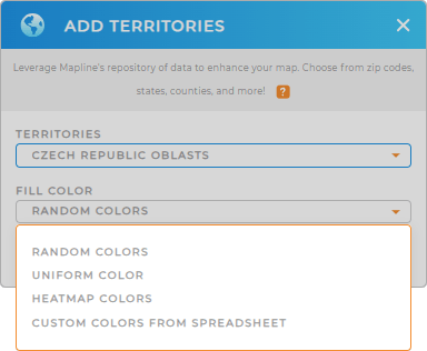
Now it’s time to enhance your territory map with color coding. By adding colors, what once took hours or even days to analyze can now be done in minutes—or even seconds! Using color in maps of regional boundaries enhances visual clarity, making it easier to identify trends, patterns, and key insights.
Choose your preferred color styles from the drop-down menu, then click OK.
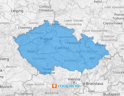
Woah! You now have a powerful map of Czech Republic oblasts for deeper analytics!

GET NEW TERRITORY INSIGHTS
Discover new location insights with the help of these powerful capabilities:
- Add a new chart to get a quick snapshot of your data
- Utilize advanced route optimization to serve your customers with ease
- Create custom sales territories in a flash


