- Blog
- Geo Mapping
- THE BEST TERRITORY MAPPING SOFTWARE OF 2026
Territory mapping software has quietly become one of the most important tools for modern businesses. As teams manage more locations, more data, and higher expectations for speed and accuracy, spreadsheets and static maps simply can’t keep up. In 2026, the difference between high-performing teams and everyone else often comes down to how effectively they turn geographic data into action.
The best territory mapping software doesn’t just visualize locations. It transforms raw data into actionable insights that guide smarter decisions across sales, operations, logistics, and planning. When territories are built on real data instead of assumptions, teams work more efficiently, leadership gains clarity, and performance becomes measurable instead of reactive.
This article breaks down what territory mapping software actually needs to do in 2026, why actionable analytics matter more than ever, and which platforms truly help teams turn data into decisions.
What Territory Mapping Software Really Does in 2026
At its core, territory mapping connects location data with business context. It takes spreadsheets, CRMs, and operational datasets and places them on a map so patterns become immediately visible. Instead of guessing where performance is strong or where resources are stretched thin, teams can see it instantly.
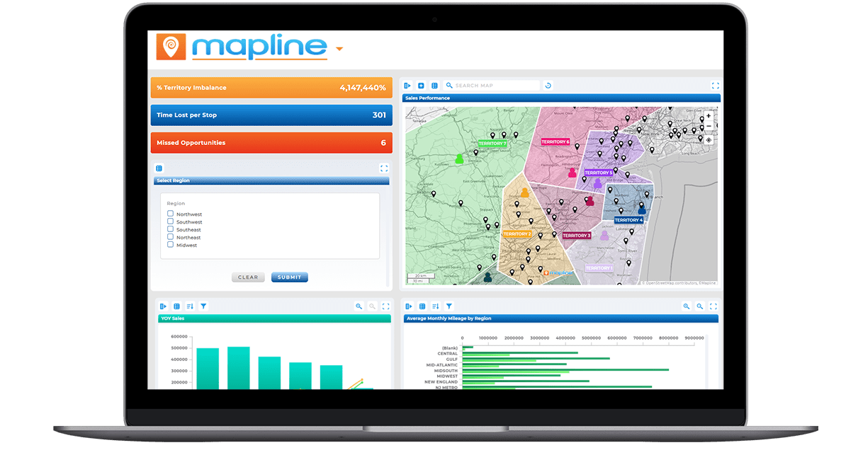
In 2026, the value of territory mapping comes from its ability to support data-driven decision making. The best tools combine geographic visualization with metrics that matter, allowing teams to understand not just where activity happens, but why results look the way they do. This shift turns maps into operational intelligence rather than static visuals.
Pro Tip: The fastest way to create actionable insights is to map the metrics you already track. Geo Mapping gives you new insight into revenue, workload, service volume, or pipeline data. All of this becomes far more meaningful when tied to geography, revealing patterns that spreadsheets alone can’t surface.
Why Actionable Insights Matter More Than Ever
Businesses are no longer short on data. The challenge is extracting insights that lead to action. Actionable insights go beyond reporting by clearly showing what needs attention, where adjustments should be made, and how decisions will impact performance.
Territory mapping software plays a critical role here by grounding analytics in geography. Revenue, workload, coverage gaps, service levels, and performance trends all look different when viewed spatially. When teams can connect metrics to regions, they move faster and make decisions with confidence instead of debate.
Turning Data Into Action With Territory Mapping
Turning data into action requires more than charts and dashboards. It requires context. Territory mapping adds that context by showing how data behaves across regions, routes, and service areas. This is what transforms business intelligence insights into operational insights.
For example, a dip in performance might look minor in a report but becomes urgent when mapped to an underserved region. Likewise, strong results may reveal opportunities to replicate success elsewhere. Territory mapping software closes the gap between analysis and execution.
What to Look For in the Best Territory Mapping Software for 2026
The best territory mapping software in 2026 is defined less by individual tools and more by how those tools work together to support real-world growth. As teams scale, territory design must move beyond static maps and manual processes that quickly become outdated. High-performing platforms are built to handle increasing data volume, shifting demand, and evolving business goals without creating friction. They prioritize intelligence over effort, replacing guesswork with systems that adapt as data changes. Most importantly, modern territory mapping solutions serve as decision-making engines, ensuring territory strategy stays aligned with performance, coverage, and outcomes over time.
True Data Scalability
World-class territory mapping software is built to scale without compromise. It supports millions of records, complex datasets, and growing teams without forcing users to simplify, split, or downsize their data. There are no artificial row limits, pin caps, or performance slowdowns as operations expand. As territory needs evolve, the platform continues to perform at the same speed and reliability. This level of scalability ensures teams never outgrow their territory strategy or the tools that support it.
Intelligent, Data-Driven Territory Design
Elite territory mapping platforms move beyond manual boundary drawing and into intelligent design. Territories are created using real operational data such as workload distribution, demand density, performance metrics, and coverage requirements. This approach ensures territories are balanced, fair, and aligned with business goals from the start. As underlying data changes, territories can be adjusted with precision instead of being rebuilt from scratch. The result is a system that reflects reality, not assumptions.
Dynamic Territory Adjustments
The best territory mapping software treats territories as living systems rather than static shapes. It allows teams to quickly adjust boundaries as customer locations shift, headcounts change, or markets expand. Updates happen without breaking downstream workflows or requiring extensive rework. This flexibility makes it easier to respond to change while maintaining consistency across teams. Dynamic territory management ensures strategies remain relevant long after initial setup.
Built-In Analytics and Performance Visibility
World-class territory mapping software connects maps directly to actionable analytics. Users can view performance metrics, summaries, and comparisons within the context of each territory rather than relying on disconnected reports. Data updates automatically, ensuring insights are always current and trustworthy. This visibility helps teams identify gaps, opportunities, and imbalances at a glance. When analytics and mapping live in the same system, territory decisions become faster and more confident.

Collaboration and Operational Alignment
Top-tier territory mapping platforms are designed for cross-team collaboration. Sales, operations, leadership, and analytics teams can work from the same source of truth without version conflicts or siloed data. Permissions and sharing controls ensure the right people have access to the right information at the right time. This alignment reduces miscommunication and speeds up execution across the organization. When everyone operates from the same territory framework, strategy turns into action more smoothly.
Platforms That Set the Standard in 2026
Several tools offer territory mapping capabilities, but only a few deliver true actionable analytics and operational insight. Among them, Mapline stands out for its ability to unify mapping, analytics, routing, and automation in one platform.
Mapline allows teams to transform data into insights without exporting spreadsheets or stitching together disconnected tools. Territories, metrics, and performance views stay synchronized, which is critical for teams making fast, data-driven decisions. This makes Mapline especially effective for organizations that rely on geography to operate efficiently.
Other tools may offer basic territory visualization or CRM-bound mapping, but they often stop short of delivering actionable analytics at scale. In 2026, the difference lies in whether a platform helps teams understand what to do next, not just what happened.
| Capability | Mapline | Salesforce Maps | eSpatial | Badger Maps | Maptive |
|---|---|---|---|---|---|
| Handles large, complex datasets without artificial limits | ✓ | ✗ | ✓ | ✗ | ✗ |
| Intelligent, data-driven territory design | ✓ | ✓ | ✓ | ✗ | ✗ |
| Dynamic territory updates as data changes | ✓ | ✓ | ✓ | ✗ | ✗ |
| Built-in analytics and territory performance metrics | ✓ | ✓ | ✓ | ✓ | ✗ |
| Territory mapping and route optimization in one platform | ✓ | ✗ | ✗ | ✓ | ✓ |
| Works with spreadsheets and live databases | ✓ | ✗ | ✓ | ✗ | ✓ |
| Single platform for territory planning, execution, and analysis | ✓ | ✗ | ✗ | ✗ | ✗ |
How Territory Mapping Enables Better Business Intelligence
Traditional business intelligence often lives in dashboards removed from daily operations. Territory mapping bridges that gap by embedding intelligence directly into planning and execution workflows. This allows leaders to move from retrospective reporting to proactive decision making.
When teams can see performance, workload, and opportunity by region in real time, they stop reacting late and start acting early. That shift is what turns data into a competitive advantage.
Territory mapping software visualizes location-based data and organizes it into defined regions or territories. It helps teams understand coverage, performance, and workload across geographic areas. The goal is to turn location data into clear, actionable insights.
Territory mapping connects metrics to geography, making trends and gaps visible instantly. This spatial context helps teams prioritize actions, allocate resources, and adjust strategies with confidence. Decisions become grounded in evidence instead of assumptions.
Business intelligence tools focus on charts and dashboards, while territory mapping adds geographic context. Territory mapping shows where results happen, not just how they look numerically. When combined, they create stronger operational insights.
Modern territory mapping software is designed to scale with large datasets. The best platforms support high-volume data without performance issues, ensuring insights remain accurate as operations grow. Scalability is essential for long-term use.
Sales teams, operations leaders, logistics teams, and executives all benefit from territory mapping. Any team that relies on location-based decisions can use it to improve efficiency, balance workloads, and uncover opportunities.
By showing exactly where performance changes occur, territory mapping makes it clear what needs attention. Teams can adjust territories, routes, or coverage areas immediately, closing the gap between analysis and execution.


