
How to Drive More Insights When Mapping Zones of Tanzania
Enhance Situational Awareness by Using Exceptional Mapping Tools
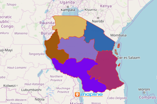
When mapping zones of Tanzania using Mapline’s mapping software, you are able to derive information-based decisions. Agriculture is the top economic factor in Tanzania, a country located in East Africa. It is divided into 7 zones. Excel data plotted within zone boundaries helps the users to create plans for field operations, situational awareness, and even preparedness when disasters strike. Mapping provides a great deal of benefits to agriculture enthusiasts including farmers and growers.
Need to identify trends? Segmenting data is highly recommended. When applied on a zones map of Tanzania, the feature allows the users to view the locations and analyze the data by segments. Leverage dynamic filters as you analyze tons of data. It lets the users customize the way the information is presented because in just a few clicks, you can show or hide locations based on their distinct characteristics. In just a few minutes, insights, patterns, and trends will come showing up!
Do More Analyses, Gain More Insights
To map Tanzania zones, just follow these 10 easy steps. But don’t just stop there! There’s a lot more that you can do on your map. The more you use more smart tools to analyze your map, the more insights you can gain. For example, territory reports will give you access to performance reports from your team.
- Create a Mapline account and login.
- Click the orange “Add New Items” button.
- Select “New Map” on the drop down arrow.
- Give your map a name and click “OK.”
- Click the “Add” button from the left sidebar.
- Select the “Territories” option.
- Click “From Mapline’s Repository.”
- From the “Territories” select “Tanzania Zones.” Use the search bar for quicker results.
- Select how you want your boundaries to be colored in “Fill Color” (Random Colors, Uniform Color, Dynamic heat map colors, or Custom colors from spreadsheet).
- Click “OK.”
Whether you’re mapping zones of Tanzania to manage an independent farm, or supervise a large farming operation, you can never go wrong with an affordable and easy-to-use mapping software. Sign up now and learn how to use all the available mapping solutions to help you discover insights in your data.