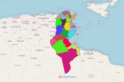
How a Map of Tunisia Showing Governorates is Used in The Export Industry
Investigate Data on a Map with Governorates Boundaries
A map of Tunisia showing governorates is an exceptional tool for spot trends when producing, marketing, and exporting goods. Tunisia is a country nestled in the northernmost part of Africa. It is divided into 24 governorates which are further divided into 264 delegations or districts. As one of the countries in Africa with the most competitive economy, Tunisia heavily relies on the export industry. Its major imports include apparel, electronics, electrical components, and food products.
A data-driven map of governorates of Tunisia helps to analyze trends thereby maximizing profits! Data matters and they tell stories! If you have historical data, overlay it on a map alongside your current data. Compare them and instantly, you get to understand the cause of the changes in costs, revenues, and total purchases. Use mapping tools such as heat maps and data segmentation to uncover what needs to be changed. Then act accordingly!

Mapping Tunisia Governorates Takes Just a Few Seconds
Set your timer to start now:
- Create a Mapline account and login.
- Click the orange “Add New Items” button.
- Select “New Map” on the drop down arrow.
- Give your map a name and click “OK.”
- Click the “Add” button from the left sidebar.
- Select the “Territories” option.
- Click “From Mapline’s Repository.”
- From the “Territories” select “Tunisia Governorates.” Use the search bar for quicker results.
- Select how you want your boundaries to be colored in “Fill Color” (Random Colors, Uniform Color, Dynamic heat map colors, or Custom colors from spreadsheet).
- Click “OK.”
That’s how easy it is to create a map of Tunisia showing governorates! Mapline also makes it simple to see summary information about the locations inside each governorate just by clicking on them! Sign up now and let our powerful mapping tools lead you at the edge of competitive advantage.


