
Map Districts of Zimbabwe to Create Viable Plans for Food Supplies and Deliveries
Promote Food Programs Using Smart Mapping Tools
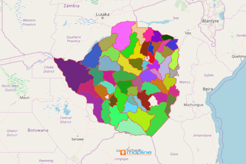
Government agencies map districts of Zimbabwe to provide basic food needs to all district population including the refugees. Zimbabwe is a country in Southeast Africa which is divided into 59 districts. As they plot population data from Excel, they are able to identify the most affected districts during severe seasonal shocks. Hence, mapping is the key to ignite ideas to create plans for nutrition drives and how to implement them. With smart mapping tools, be empowered to get all the great insights derived from adding location data as you map Zimbabwe districts.
Because time is critical for food programs, Mapline’s advanced route mapping allows the users to create and optimize route plans to increase efficiency. Upload a list of delivery stops like warehouses, distribution centers, store locations, local addresses, or anything else. Since Mapline can support huge amounts of spreadsheets, you can create even bulk routes with no problems at all. Through routing, the health department can ensure efficient and cost-effective supply chain services to provide procurement expertise and logistics services.
Get The Best Uses of Zimbabwe District Map
After following these 10 simple steps, your map will be generated in a few seconds. You’ll be amazed to know that more mapping tools such as heat maps and drawing customized territories will help you even further to identify specific district areas that need help the most. As you click on the customized shape, it will show you a list of all the addresses located within the shape. This is extremely helpful when analyzing the workloads of each health representative.
- Create a Mapline account and login.
- Click the orange “Add New Items” button.
- Select “New Map” on the drop down arrow.
- Give your map a name and click “OK.”
- Click the “Add” button from the left sidebar.
- Select the “Territories” option.
- Click “From Mapline’s Repository.”
- From the “Territories” select “Zimbabwe Districts.” Use the search bar for quicker results.
- Select how you want your boundaries to be colored in “Fill Color” (Random Colors, Uniform Color, Dynamic heat map colors, or Custom colors from spreadsheet).
- Click “OK.”
Create the most viable plans to promote health and food programs using smart mapping tools as you map districts of Zimbabwe. Sign up now and be empowered by different mapping tools to create data-based plans to promote food programs.