BANGLADESH DISTRICTS
- Territory Guide
- BANGLADESH DISTRICTS
Unlock the power of building a custom map of Bangladesh districts to supercharge your business strategies! Creating a custom district map isn’t just a task—it’s a game-changer for businesses looking to make smarter, data-driven decisions. Revolutionize your operations using this powerful visualization tool as you aim to establish customer segmentation that clicks. Break down your customer base by district to craft hyper-local marketing strategies.
Imagine tailoring your campaigns to the unique needs and preferences of Dhaka, Chattogram, or Sylhet. It’s not just targeting; it’s precision! Let’s check it out together.
WHAT ARE BANGLADESH DISTRICTS?
Bangladesh, a vibrant South Asian nation, thrives through its intricate governance structure of eight divisions and 64 dynamic districts. At the helm of each district stands the Deputy Commissioner (DC), a pivotal figure ensuring administrative excellence. District councils, the heartbeat of local governance, shape the region’s future by crafting essential infrastructure—from roads and bridges to schools and hospitals. They champion public health through sanitation projects and ensure access to clean drinking water with tube wells. Together, these councils drive progress, turning aspirations into reality for millions.
Analyzing at the district level unlocks a treasure trove of insights, propelling your business strategies to unparalleled heights. It’s about diving into the granular details others might overlook, gaining a competitive edge with every discovery.
ADD BANGLADESH DISTRICTS
Get ready to elevate your approach and map out Bangladesh districts in no time. With clearly defined district boundaries, you equip yourself with an extraordinary level of precision and clarity for strategic planning.
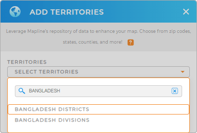
Ready to turn your data into a powerhouse of actionable insights? Let’s dive in and add a new territory from Mapline’s repository then! In the search bar, type BANGLADESH to easily choose to add BANGLADESH DISTRICTS to your map.
That’s so convenient!


Pro Tip: Leverage Mapline’s Territory Repository to supercharge your analysis. With its extensive collection of worldwide territory boundaries—including Bangladesh divisions and districts—you’ll have the precise tools to conduct in-depth territory analysis.
CHOOSE DISTRICT COLORS
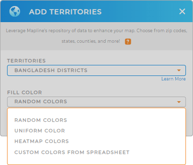
Bring your territory map to life with territory colors! They are a powerful visualization aid to help unlock insights at a glance! Color-code your district map and create a dynamic visual narrative that turns data into an intense masterpiece!
Choose the color styling that matches your type of analysis. Once generated, click OK.
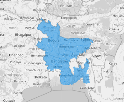
Now, there’s your map of Bangladesh districts waiting to be explored.

GET NEW TERRITORY INSIGHTS
Stir up your analysis a step further as you leverage these powerful capabilities:
- See the big picture of your data patterns
- Integrate all your business information in one system for a cohesive view of your business
- Build a tailored optimization delivery route plans for utmost efficiency


