BUENOS AIRES CITY NEIGHBORHOODS
- Territory Guide
- BUENOS AIRES CITY NEIGHBORHOODS
Unlock the potential of your sales strategy by mapping out Buenos Aires City neighborhoods. Visualizing these areas can transform how you manage sales territories, helping you pinpoint high-opportunity zones, optimize routes, and allocate your team with precision. Imagine having the insights to see exactly which regions demand more focus and which are already flourishing. A Buenos Aires city neighborhood territory map can be a game-changer for your sales team, allowing them to focus on key areas, identify top-performing regions, and zero in on places that need additional resources.
Harness the power of a detailed neighborhood map today to boost sales efficiency and drive unstoppable growth. Let’s dive into adding these administrative boundaries to your map now!
WHAT ARE BUENOS AIRES CITY NEIGHBORHOODS?
Argentina’s capital is a buzzing metropolis that offers more than first impressions—each neighborhood has its own unique atmosphere and character, inviting you to explore and discover. A map of Buenos Aires’ 48 neighborhoods (locally known as barrios) is the perfect gateway to truly understanding Argentina’s vibrant capital. Each neighborhood, from the historic charm of San Telmo to the bustling energy of Palermo, offers its own unique character and charm. By exploring the city’s diverse areas through this detailed map, you’ll gain valuable insights into Buenos Aires—the largest and most dynamic city in Argentina—setting the stage for a deeper connection with your customers and target markets.
With this strategic map of city neighborhoods, you can direct your sales efforts where they’ll have the most impact, ensuring optimal coverage and maximizing your reach for greater success.
ADD NEIGHBORHOODS
Mapping Buenos Aires city neighborhoods can revolutionize your sales strategies by offering clear, actionable insights into regional performance. With this detailed view, be empowered to make informed, data-driven decisions that optimize your sales operations!
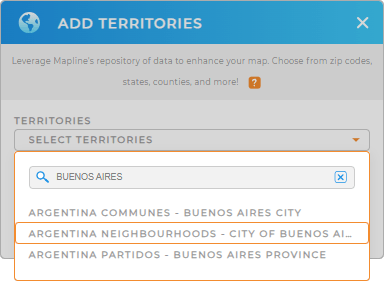
To add a new territory from Mapline’s repository, type ARGENTINA into the search bar and select ARGENTINA NEIGBORHOODS from the drop-down menu. This is the quickest way to add the right territory to your map.
You’re almost done, there’s just one more quick step!


Pro Tip: Mapline’s comprehensive list of territory boundaries enables you to add precise regional divisions to your maps effortlessly. With access to territories worldwide, explore and integrate various regional boundaries, including Argentina departments, Argentina provinces, Argentina communes, neighborhoods, and Argentina partidos, to gain a deeper understanding of regional dynamics.
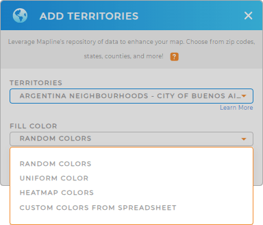
CHOOSE NEIGHBORHOOD COLORS
Territory colors are a vital tool for business analytics, making it easy to visualize sales performance at a glance. By color-coding Buenos Aires City neighborhoods, you can quickly spot high-performing areas and identify those that need more attention. This simple yet powerful technique helps you optimize operations and make strategic decisions faster, ensuring your sales efforts are always targeted for maximum impact.
Select your desired preferred territory color styles , then click OK.

GET NEW TERRITORY INSIGHTS
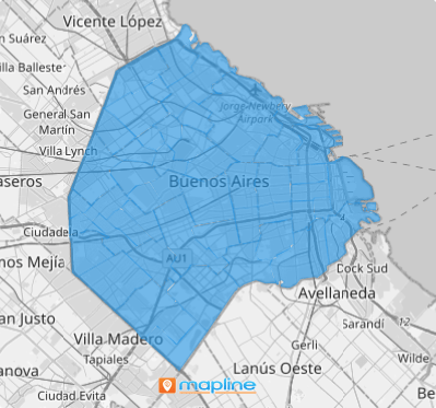
That’s how simple it is to create a map of Buenos Aires City neighborhoods! But the benefits don’t end there. Use these mapping capabilities to reveal patterns, optimize your strategy, and make more informed decisions that drive growth and efficiency.
- Optimize sales routes for reduced travel time and increased efficiency
- Target specific customer segments as you filter your sales data
- Run advanced calculations to uncover granular sales trends and market opportunities unique to Buenos Aires


