CARIBBEAN COUNTRIES
- Territory Guide
- CARIBBEAN COUNTRIES
Add the boundaries of Caribbean countries to your map to unleash insights and transform how you operate your business in the Caribbean! By seamlessly integrating custom maps into your analytic toolkit, you’re not just observing patterns—you’re unlocking actionable insights. This approach empowers you to make informed, strategic decisions, driving growth, efficiency, and a competitive edge in every market they serve. Dive into the details, analyze like a pro, and watch your business thrive with smarter strategies and sharper decisions.
In just a few seconds, you can supercharge your analysis using this country map. Let’s get started!
WHAT ARE CARIBBEAN COUNTRIES?
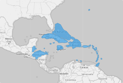
The Caribbean, a captivating subregion nestled in the middle of the Americas, is centered around the vibrant Caribbean Sea in the North Atlantic Ocean. Stretching from The Bahamas in the north to Guyana in the south, and from Suriname in the east to Belize in the west, it encompasses a vast expanse of ocean and land. Covering approximately 1,000 miles north to south and over 2,500 miles east to west, the Caribbean is a dynamic region bursting with cultural diversity and natural beauty.
For successful brands, a detailed map of Caribbean country territories is more than a tool—it’s a catalyst for transformation. By leveraging this map, you unlock the ability to make smarter decisions, uncover cost-effective opportunities, and establish a powerful, location-driven brand presence in the Caribbean. Country-level analysis becomes your secret weapon, revealing untapped potential and driving precision in every move.
ADD CARIBBEAN COUNTRIES
Start analyzing the Caribbean country boundaries today, and watch how it transforms your approach to strategy and decision-making. With this map, you unlock the full potential of your data, revealing insights that can elevate your business operations, marketing, and logistics.
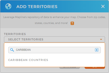
Create your Caribbean country map and ignite the possibilities! First, add a new territory from Mapline’s repository. Type CARIBBEAN in the search bar. It will direct you to click on CARIBBEAN COUNTRIES to add to your map.
One last easy step and we’re good to go.


Pro Tip: Mapline’s worldwide territory repository lets you add precise boundaries of Caribbean countries to your map in seconds! Explore new opportunities and gain deeper insights into the territories of individual countries in the Caribbean including The Bahamas, Barbados, and more.
CHOOSE COUNTRY COLORS
Be empowered to see beyond the lines in your map. Embrace the power of color-coded analytics! Applying territory colors opens the way to revolutionize the way you operate your business, craft marketing strategies, and streamline logistics.
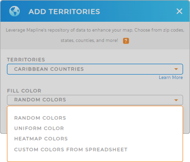
Mapline designs the best color styles to choose from. Select from random colors, custom colors, heat map, or uniform color, and get ready to be wowed by amazing insights.
Click OK to wrap up the process of creating your map of Caribbean countries.

GET NEW TERRITORY INSIGHTS
You may want to add these powerful capabilities to your territory analysis:
- Segment your locations to visualize which areas have the highest sales conversions
- Create a dashboard that lets you understand trends and patterns
- Learn the average sales or customer counts in a folder report


