CONGO-BRAZZAVILLE DEPARTMENTS
- Territory Guide
- CONGO-BRAZZAVILLE DEPARTMENTS
A map of Congo-Brazzaville departments is your ultimate advantage in analytics. Leading brands harness this analytical approach, leveraging department mapping to refine their location decisions and revolutionize their operations. Imagine transforming raw numbers into powerful insights by visualizing your business performance within department boundaries! What you’ll see are the most complex business challenges turning into golden opportunities. How awesome is that!
Ready to leave rivals in your wake and drive unparalleled growth? Let’s get started!
WHAT ARE CONGO-BRAZZAVILLE DEPARTMENTS?
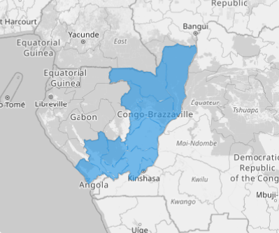
The Republic of the Congo, also known as Congo-Brazzaville, or simply Congo, is located on the western coast of Central Africa, to the west of the Congo River. It is divided into 12 departments, which replaced former regions in 2002. These departments serve as the first-level divisions in the country, playing a central role in administration and governance.
Department-level mapping doesn’t just keep you in the race—it propels you to the front! It’s about capturing every insight to fuel precise market analysis. Spot your strongest areas, address weaknesses, and build a strategy that outshines the competition.
ADD CONGO-BRAZZAVILLE DEPARTMENTS
Create a map of Congo-Brazzaville departments in seconds and kickstart your journey to understanding your customers on a whole new level. With this powerful map, you can unlock customer insights to design products, services, and marketing strategies that truly resonate with your audience, ensuring your business stays relevant and ahead of the curve.
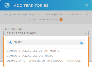
Start mapping your success today as you add a new territory from Mapline’s repository. Type CONGO in the search bar and select CONGO-BRAZZAVILLE DEPARTMENTS.


Pro Tip: Tap into Mapline’s worldwide territory repository and easily add territories to your map including Congo-Brazzaville Congo-Brazzaville districts and departments.
CHOOSE DEPARTMENT COLORS
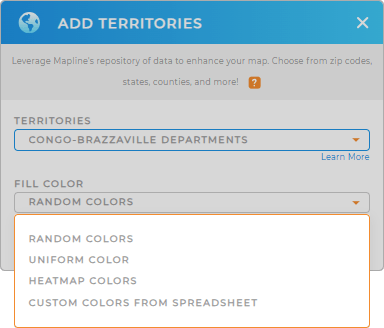
Now, here’s the real game-changer: Integrate colors into your department map to capture hyper-focused insights in an instant! Color coding your map represents different data sets such as customer density, competitor locations, or market potential. This helps in visualizing and interpreting complex data.
Elevate your map’s visual impact and effectively highlight key information with the right color styling. It’s a powerful tool to draw insights for better decision-making.

GET NEW TERRITORY INSIGHTS
Unlock the full potential of your map of Congo-Brazzaville departments by integrating these powerful capabilities:
- Perform advanced calculations to uncover hidden trends
- Filter your data to view specific performance metrics
- Manage data information with Mapline API for streamlined efficiency


