ESTONIA SETTLEMENTS
- Territory Guide
- ESTONIA SETTLEMENTS
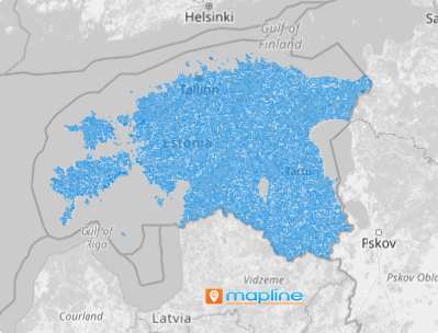
Smart business decisions start with strategic thinking, and a map of Estonia settlements can be your secret weapon. This level of analysis isn’t just beneficial—it’s transformative! Picture this: uncovering hidden insights that were always there, just waiting for the right tools to bring them to light. By leveraging this territory map in your analysis, you gain a sharper, more focused perspective on regional trends and dynamics. This clarity empowers you to understand what’s happening across different settlement units and how these insights can shape your business strategies.
It’s not just about seeing the bigger picture—it’s about discovering the details that drive smarter, more impactful decisions.
WHAT ARE ESTONIA SETTLEMENTS?
Estonia, a picturesque nation by the Baltic Sea in Northern Europe, features a unique distinction between its administrative and settlement units. Settlement units, which include villages, small boroughs, boroughs, and towns, reflect the population size and character of communities across the country.
- Villages typically have fewer than 300 residents, offering a quiet, rural charm
- Small boroughs are home to 300 to 1,000 people, serving as vibrant small communities
- Boroughs and towns, with populations exceeding 1,000, embody Estonia’s larger and more urbanized areas
This system highlights Estonia’s diverse living environments, from tranquil countryside settings to bustling urban centers.
Get ready to unlock the full power of this map! By analyzing your business performance within these boundaries, you can achieve remarkable results and become an unstoppable force in your market. The future is yours to shape—seize it!
ADD ESTONIA SETTLEMENTS
A settlement-level analysis can revolutionize your business operations, fine-tune your marketing strategies, and uncover hidden opportunities that were previously out of reach. By diving deep into the details, you’ll gain the insights needed to make smarter, more impactful decisions.
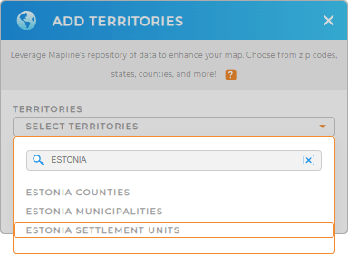
Add a new territory from Mapline’s repository in just a few seconds! Use the search bar and type ESTONIA. Then, click on ESTONIA SETTLEMENT UNITS.
How fast is that!


Pro Tip: Tap into Mapline’s global territory repository of pre-defined territory boundaries to uncover new insights! Compare and contrast how different administrative boundaries impact your operations in Estonia, including Estonia counties, Estonia municipalities, and settlements.
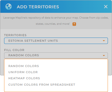
CHOOSE SETTLEMENT COLORS
Bring your A-Game into your analytics as you apply territory colors. Colors ignite ideas and highlight focus areas so you can make the necessary adjustments to your strategies.
Start mapping success today by selecting the best color styles and watch your map come to life with real-time insights.
Lastly, click OK to start delving into your map.

GET NEW TERRITORY INSIGHTS
Leverage these powerful capabilities to get the most out of your map of Estonia Settlements:
- Improve your data visualization with custom pin styling
- Upload large datasets in seconds to access powerful insights without the hassle
- Add metrics to access instant, up-to-date summary of data


