GUYANA REGIONS
- Territory Guide
- GUYANA REGIONS
Visualizing your target market on a map of Guyana regions unlocks valuable insights that can transform your analytics and operational efficiency. Understanding the lucrative markets within the country is the key to driving business growth, especially for budding entrepreneurs. One of the most effective ways to do this is by creating a map with well-defined, granular geographic boundaries. Dive deep into local demographic trends and leverage the insights when tailoring your sales strategies.
Grasp the nuances of each local market to craft data-driven strategies that put your business operations up a notch. With a Guyana region map, gain the insight needed to optimize operations and identify opportunities.
WHAT ARE GUYANA REGIONS?
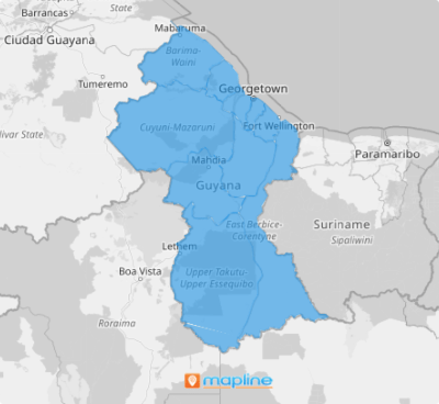
Guyana is divided into 10 regions, each with its own unique economic and geographic profile. By utilizing a detailed map of these regions, businesses can conduct quick and insightful analysis leading to better decision-making and higher productivity. Harness the power of region-level mapping and watch your business catapult to success as it responds accordingly to market changes.
Region-level mapping offers a comprehensive view of Guyana’s 10 regions, allowing businesses to visualize key insights and make informed decisions that fuel growth. Whether it’s optimizing resource distribution, improving logistics, or gaining insights into local market trends, this tool enables organizations to break down complex information into clear, actionable insights.
ADD GUYANA REGIONS
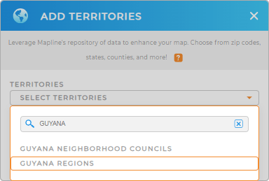
Create a map with region boundaries to identify trends and relationships. Transform insights into actionable information! Mapline makes it easy to start mapping. Just follow these easy steps starting by adding a new territory from Mapline’s repository. Type GUYANA into the searchbar and choose GUYANA REGIONS.
You’re done with the first step. We’re pretty sure you’re gonna love the next step then – applying territory colors.


Pro Tip: Mapline’s Repository houses a comprehensive list of worldwide territory boundaries including Guyana regions and Guyana neighborhood councils. Go ahead and add precise regional divisions to your map in seconds to get the insights needed to craft strategies for sales, marketing, logistics, and more.
CHOOSE REGION COLORS
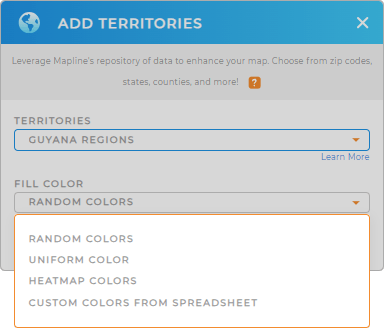
Speed up your analysis even more with territory colors. Colors are a powerful enhancement for your analytical approach. Here in Mapline, you can apply either static or dynamic colors. Apply status colors to your territories to get a clear visual distinction between regions, making it easier to interpret your data at a glance. But if you want to elevate your analysis to the next level, apply dynamic colors that are directly linked to your data metrics.
Let’s harness the power of color to transform your data into a vivid narrative by applying your preferred color styles.

GET NEW TERRITORY INSIGHTS
Dive deeper into your analysis using Mapline’s advanced capabilities:
- Generate pins from your spreadsheet data in just a few seconds
- Calculate store performances based on metrics you defined
- Create optimized routes


