INDIA STATES AND TERRITORIES
- Territory Guide
- INDIA STATES AND TERRITORIES
Make your map of India states and territories a key analytical factor as you unlock a deeper understanding of your business’s regional performance. This powerful visualization offers a clear comparison of how well your business is doing across various areas, bringing to light the regions where you’re thriving and those that need focused improvement. Armed with these insights, you can make smarter, data-driven decisions to fine-tune your strategies and accelerate growth in the areas that will have the greatest impact. Imagine having the power to organize your data like a seasoned strategist! This level of analysis gives you a distinct advantage, allowing you to visualize where your next big success lies.
Let’s check out how you can easily add these boundaries to your map fast!
WHAT ARE INDIA STATES AND TERRITORIES?
India, one of the world’s fastest-growing major economies, presents immense opportunities for businesses eager to expand. With 28 states and 8 union territories, navigating this vast market can be overwhelming. Where should you focus your efforts? That’s where Mapline comes in. Add these administrative boundaries to your map in seconds! Once you have your map up and running, you can strategically visualize and plan your business expansion with confidence. Whether you’re planning a brand expansion or conducting market research, having this visual tool at your disposal will set you on the path to success.
Let’s get you adding these administrative boundaries to your map now!
ADD INDIA STATES AND TERRITORIES
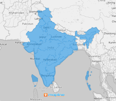
With India’s states and territories added to your map, you can start expanding your customer base, analyzing trends, and gaining a deeper understanding of your customers’ needs. This detailed visualization provides valuable insights, helping you spot growth opportunities and refine your strategies to better serve your markets.
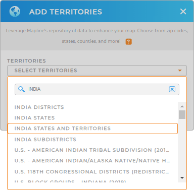
To add a new territory from Mapline’s repository, simply type in INDIA in the search bar and select INDIA STATES AND TERRITORIES.
Wow, that’s lightning fast!


Pro Tip: Leverage Mapline’s Territory Repository to supercharge your analysis. With its extensive list of worldwide territory boundaries—including India states and territories, India districts, and India subdistricts—you’ll have the precise tools needed to conduct thorough territory analysis.
CHOOSE STATE AND TERRITORY COLORS
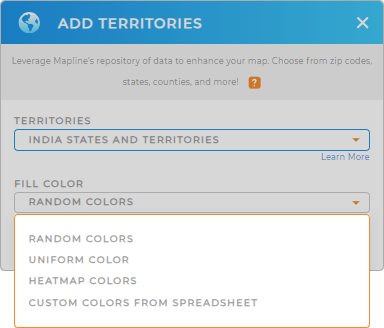
Now, get ready to uncover more opportunities that can elevate your business to new heights as you fill your territory with colors. Colors are integral for producing an effective visualization. Color-coding your territory map helps to effortlessly identify key factors and trends and make informed decisions that can impact your business operations.
Strategically apply the best type of colors and start collecting valuable insights to adjust your strategies.
Now, you have a robust map that offers new insights!

GET NEW TERRITORY INSIGHTS
Embrace the journey of data analytics with these advanced capabilities that can help level up your business strategies:
- View territory data to unveil deeper insights
- Manage your sales operations to keep track of your sales performance
- Seamlessly add charts, reports, and maps to your dashboard


