LEBANON DISTRICTS
- Territory Guide
- LEBANON DISTRICTS
Elevate your analysis to the next level by harnessing the power of a detailed map of Lebanon districts. By visualizing customer locations on a map of district boundaries, brands are tapping into something extraordinary. They’re uncovering local trends, gaining deep insights into customer buying behaviors, and staying ahead in an ever-evolving marketplace. This district map is not just a tool; it’s a game-changer!
Enhance your ability to visualize different perspectives in a way that puts you ahead of the competition, letting you shine like never before. If you’re looking for a powerful way to bring your district insights to life, get ready—because you’re in for a treat!
WHAT ARE LEBANON DISTRICTS?
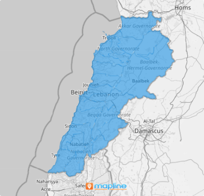
Lebanon, located in the Levant region of West Asia, is divided into nine governorates, further subdivided into 25 districts. However, Beirut Governorate stands alone, as it is not subdivided into districts, while Akkar Governorate is unique in that it consists of only a single district. The clarity of each district boundaries is seen at a glance once you add these administrative boundaries to your map.
Dive into a district-level analysis and uncover those hidden gems waiting to be revealed. Each district has its own unique story, and now, you can make your map not just a tool, but a dynamic narrative that speaks directly to the heart of your market. When you tap into the needs of each district, you’re giving your brand the power to connect in deeper, more meaningful ways. Let your map guide you to success!
ADD LEBANON DISTRICTS
Get ready to be a true trailblazer in your industry! Imagine the power of pinpointing key data points easily revealed on a map of Lebanon districts including regional patterns, emerging trends, and deep customer insights. Instantly apply these game-changing insights to your strategies, propelling your business to new heights of success.
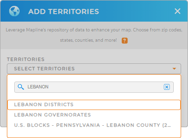
To create a powerful map visualization, start by adding a new territory from Mapline’s repository. Type LEBANON and select LEBANON DISTRICTS from the selection.
Easy peasy!


Pro Tip: Easily add Lebanon territory boundaries including Lebanon governorates and districts when you access Mapline’s extensive list of territory boundaries. It houses hundreds of territories from all over the world to help you unlock powerful new insights.
CHOOSE DISTRICT COLORS
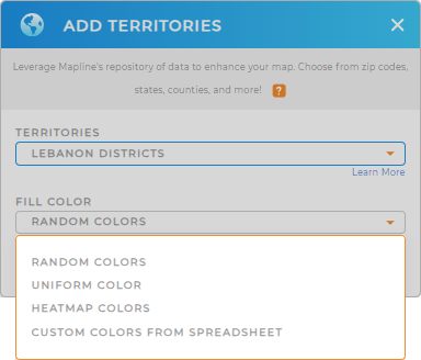
Now. Let’s talk colors. Imagine making your data come alive with vibrant, dynamic hues that change in real time. In Mapline, you can apply dynamic colors fully connected to your data, updating instantly to give you the freshest, most accurate insights. With every shift in your data, you’ll see the story unfold in bold, beautiful colors, making it easier to spot trends and drive your strategy forward. This is data visualization like never before—and it’s yours to harness!
Just choose your preferred color styles to match your level of analysis. Once you have configured your settings, click OK.
You’ve just created a map of Lebanon districts ready to be analyzed.

GET NEW TERRITORY INSIGHTS
Adding Lebanon districts to your map is just the start. Now, add these Mapline’s advanced capabilities to help you unlock more insightful values from your data:
- Add labels to your map for clarity
- Visualize key data and analyze results with customized charts
- Align your strategic business goals with real-time data as you generate intelligent sales forecasts


