LIECHTENSTEIN DISTRICTS
- Territory Guide
- LIECHTENSTEIN DISTRICTS
Uncover location-based insights by overlaying your perspectives onto a map of Liechtenstein districts. This powerful visualization enables you to identify trends, assess regional dynamics, and make data-driven decisions that enhance your strategic approach and drive success in each area. Analyzing at the district level offers clearer insights into regional demographic patterns and trends, allowing you to tailor strategies to meet the specific needs of each district. Visualizing your market potentials on a district map sparks new ideas and empowers you to make informed decisions—whether for market penetration, optimizing logistics, or resource allocation—helping you unlock greater potential in every region.
Let’s take a look into adding this territory to your map quickly.
WHAT ARE LIECHTENSTEIN DISTRICTS?
A Liechtenstein district map is an invaluable tool for conducting data and territory analyses. This small European nation, nestled between Austria and Switzerland, is composed of 11 municipalities grouped into two districts: Unterland and Oberland. There’s far more to discover beyond these simple divisions. Mapping insights within these districts reveals deeper patterns and connections, allowing for more enhanced analysis and a better understanding of Liechtenstein’s unique regional dynamics.
Integrate your customer locations to visualize how each district performs at a glance. Uncover the connections between each area and data relationship to territorial boundaries. This visualization empowers you to foresee crucial factors—risks, potentials, and opportunities—allowing you to make informed decisions with confidence.
ADD LIECHTENSTEIN DISTRICTS
Utilize a map of Liechtenstein districts as a central tool in your data analysis. Its powerful visualization capabilities allow you to easily identify high-potential areas and customize your strategies to align with local demands, giving you a competitive edge in targeting key regions.
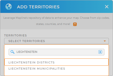
To add a new territory from Mapline’s repository, type LIECHTENSTEIN in the search bar and choose to add LIECHTENSTEIN DISTRICTS.
One last step and we’re good to go.


Pro Tip: Effortlessly consolidate regions from multiple countries, including Liechtenstein municipalities and districts, using Mapline’s vast repository of worldwide territories. By leveraging territory maps in your analysis, you’ll enhance the depth and accuracy of your data and location insights, leading to informed decision-making.
CHOOSE DISTRICT COLORS
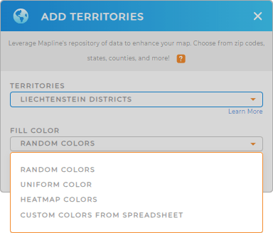
Bring your map to life and make it more as you fill in your territory colors. To extract the best insights, Mapline provides different types of color schemes to help highlight key data points, making them easier to interpret and act on. For instance, applying heat map colors can reveal intensity levels across regions, helping you spot hot spots of activity at a glance. This visual approach enhances your ability to make informed, strategic decisions.
Choose the color styling for your analysis, then hit OK.
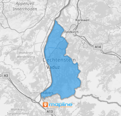
Now, there’s your map of Liechtenstein Districts ready to be utilized.

GET NEW TERRITORY INSIGHTS
Level up your strategies by harnessing these powerful capabilities as you analyze your data on a map of Liechtenstein’s districts:
- Generate detailed maps of customer locations and track deliveries in a flash
- Add Mapline Data to get the most advanced calculations to get new insights
- Analyze your data faster when you filter your data


