MOZAMBIQUE DISTRICTS
- Territory Guide
- MOZAMBIQUE DISTRICTS
Plot your insights on a map of Mozambique’s districts and watch powerful patterns emerge! District boundaries offer a powerful lens for understanding your customers and their buying patterns. By diving into district-level intelligence, you can pinpoint where your customers are, decode their behaviors, and uncover their true preferences. This granular approach is why more brands leverage district-level mapping for sharper market analysis. It’s all about precision! Targeting specific districts enables you to craft marketing campaigns that resonate more deeply with local audiences.
Let’s dive in and quickly turn your data into a strategic advantage!
WHAT ARE MOZAMBIQUE DISTRICTS?
Mozambique’s 128 districts form the backbone of its provinces. Leveraging these administrative divisions on a map is a game-changing strategy for decoding consumer demographics and preferences. This granular approach allows you to pinpoint where consumer behaviors shift, giving you the power to craft marketing strategies that are not just tailored, but highly targeted.
Let’s say you’re a sales team manager aiming to hone in on hyper-local purchasing patterns. By mapping impacting factors across Mozambique’s districts, you unlock a powerful lens into the unique needs and interests of each target market. How awesome is that?
ADD MOZAMBIQUE DISTRICTS
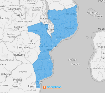
Map out those districts and turn your insights into impactful, results-driven strategies! Enhancing your map with district boundaries is a powerful strategy to boost operational efficiency, strengthen brand visibility, and drive higher conversion rates.
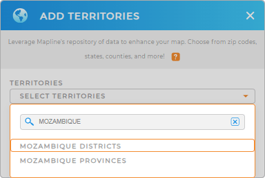
To harness the powerful ability of a district map, first, you need to add a new territory from Mapline’s repository. Type MOZAMBIQUE into the search bar and select MOZAMBIQUE DISTRICTS.
That simple step leads you to uncover patterns you may not know exist.


Pro Tip: Tap into Mapline’s territory repository to instantly add regions like Mozambique provinces and districts to your map. Explore various regional boundaries and uncover a wealth of territory insights you may have never realized existed.
CHOOSE DISTRICT COLORS
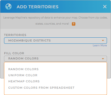
Accelerate your analytics with color. Use territory colors to reveal spatial patterns, trends, or concentrations. In Mapline, opt for a heat map to display resource allocation intensity, or choose custom colors to visually distinguish districts on your map.
Whatever color styles you choose, you’re a winner as Mapline provides the best color styling suited for any type of analysis.
With your new map of Mozambique districts, you can get started with your analysis anytime, anywhere!

GET NEW TERRITORY INSIGHTS
Fire up your data analytics as you leverage these powerful capabilities:
- Administer midpoints to help you gauge the best travel time and reduce cost
- Easily identify active vs inactive customers
- Streamline your efficiency when you manage your information with Mapline API


