NEW ENGLAND CITY AND TOWN AREAS
- Territory Guide
- NEW ENGLAND CITY AND TOWN AREAS
A map of New England City and Town Areas helps wring out important details and insights that can be useful in planning marketing campaigns across different states, managing supply chains, or monitoring sales performance. With a deeper understanding of your data, you can craft strategies that hit the mark! Break into untapped markets, optimize logistics for maximum efficiency, and build stronger connections with your customers using the insights you gather in this level of analysis.
Unlock the potential to drive smarter decisions and achieve business success as you add these boundaries to your map, Check it out!
WHAT ARE NEW ENGLAND CITY AND TOWN AREAS?
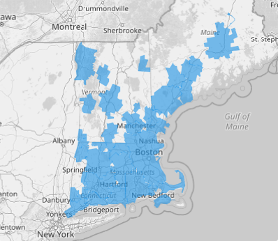
The New England City and Town Areas (NECTAs) are a vibrant framework that captures the essence of metropolitan and micropolitan regions across six iconic New England states: Connecticut, Maine, Massachusetts, New Hampshire, Rhode Island, and Vermont. These boundaries are shaped by the March 2020 delineations from the U.S. Office of Management and Budget, which provide a snapshot of the dynamic urban and rural landscapes that make New England a unique and cohesive region.
Take your mapping to the next level! Whether you’re optimizing logistics, boosting sales, fine-tuning marketing strategies, or tackling challenges in any sector, this powerful tool equips you to streamline operations with unmatched accuracy and insight.
ADD NEW ENGLAND CITY AND TOWN AREAS
Effortlessly add detailed city and town area boundaries to your map. Unlock the power to amplify your business insights and leverage data in ways you never thought possible, turning complex information into actionable strategies that drive success and innovation.
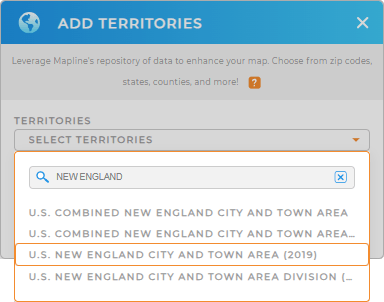
Adding territories to your map is a breeze in Mapline. Simply add a new territory from Mapline’s repository. Type NEW ENGLAND in the search bar and choose NEW ENGLAND CITY AND TOWN AREAS.
Isn’t that handy?


Pro Tip: Mapline’s Repository provides the most up-to-date city and town areas for New England, sourced directly from the U.S. Census Bureau. To ensure you’re working with the most accurate boundaries, simply select the latest year from the drop-down menu.
CHOOSE CITY AND TOWN AREA COLORS
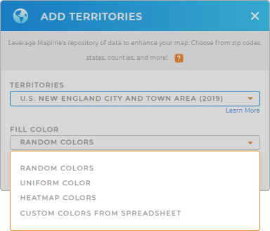
Now get ready to apply territory colors. Colors are powerful visual tools that bring your map of city and town area divisions to life, sparking insights that sharpen your sales analysis and drive market expansion. For example, use colors to represent sales volume—green for high sales and red for low sales—to instantly visualize performance across New England. Or, apply heat map colors to highlight areas with the highest growth potential, based on demographic data and market trends. With these dynamic visualizations, you can make data-driven decisions that fuel your business success!
Choose from Mapline’s color styling options. Then, click OK. Now you’ve just created a powerful map of New England city and town areas.

GET NEW TERRITORY INSIGHTS
Now boost your analysis by leveraging these powerful capabilities:
- Use distinctive pin styles to represent different sales territories
- Draw territories to your liking
- Leverage optimal routes in seconds


