NIGER REGIONS
- Territory Guide
- NIGER REGIONS
Dive into region-level analysis using a map of Niger regions to gain a competitive edge through detailed insights that can outpace competitors. Understanding geography at a region level is essential, as location is the foundation of any robust business strategy. By diving into region-level analysis, you can spot growth opportunities, allocate resources strategically, and improve service delivery based on local needs and preferences.
Leverage region-level mapping today to help you make enhanced data-driven decisions that boost efficiency, profitability, and sustainable growth in today’s dynamic business landscape. Let’s set this map for you in just 60 seconds or less!
WHAT ARE NIGER REGIONS?
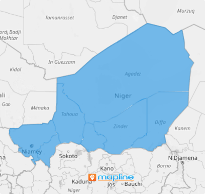
Niger, a landlocked country in West Africa, stands at the crossroads of North Africa and Sub-Saharan Africa. As the largest country in West Africa and the sixth largest in Africa, it spans diverse terrains and cultural regions. Administratively, Niger is divided into seven regions plus one capital district, providing a structured framework for governance across this vast nation.
Map these region boundaries and add unparalleled precision to your analytics! It empowers you to learn more about your market coverage, enabling you to tailor your approach more accurately. Unlock comprehensive insights that lay the groundwork for smarter, more effective strategies, driving your business toward greater efficiency and growth.
ADD NIGER REGIONS
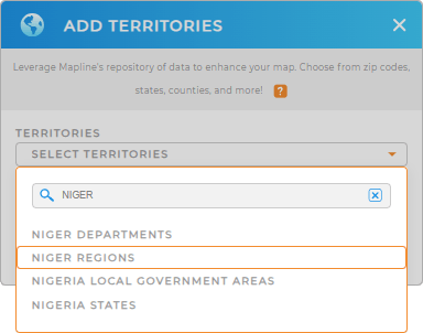
Add a new territory from Mapline’s repository starting with typing NIGER in the search bar and click to add NIGER REGIONS.
How convenient is that?


Pro Tip: Explore the different territories in Niger including Niger departments and regions available in Mapline’s repository to enhance your data and territory analysis. By leveraging Niger territory boundaries, new opportunities will emerge leading to informed decision-making.
CHOOSE REGION COLORS
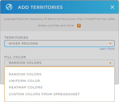
Now, let’s move on to the last step. We’re sure you’re going to enjoy applying territory colors. Color-coded territories on a map greatly enhance visualization, allowing you to distinguish between regions and uncover valuable patterns and insights easily. Whether you’re analyzing customer demographics, planning for business expansion, or optimizing customer service, this visual clarity can be a game-changer in driving strategic decisions.
Choose the best color styles that help you uncover pattens and insights at a glance.
Lastly, click OK to wrap up the process of creating a map of Niger regions.

GET NEW TERRITORY INSIGHTS
Your map of Niger regions can be a more powerful visualization tool as you adapt these advanced capabilities:
- Create instant customer and market maps to track purchasing behavior real-time
- Run a comprehensive market analysis in seconds
- Seamlessly plot the most efficient routes in seconds


